Bleaberry Tarn, Coast to Coast
More Articles in the Ennerdale Bridge to Rosthwaite subsection
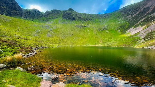
Bleaberry Tarn with Chapel Crags along the Ridge Top
Bleaberry Tarn, Buttermere, Coast to Coast
Bleaberry Tarn is a secluded glacial corrie lake nestled below the summit of Dodd (641 m), a minor peak on the High Stile Ridge with Nuttall status. Its dark waters sit beneath steep crags and grassy flanks, enclosed by the towering walls of Red Pike, Chapel Crags, and High Stile. Dodd forms the western rim of the corrie, connected to Red Pike via a high col known as The Saddle, which dips to 620 m before rising again to Dodd’s rounded top.
Although Bleaberry Tarn lies on the far side of the High Stile Ridge from the Coast to Coast path in Ennerdale, it is easily reached by climbing the forest break near High Gillerthwaite. This makes a fine alternative route to Honister, joining the ridge at Red Pike and continuing over High Stile, High Crag, and Seat, with Haystacks as an optional finale.
For those aiming solely to visit the tarn, the easier ascent is from Buttermere, through the trees of Burtness Wood and up beside Sourmilk Gill.
Bleaberry Tarn & Chapel Crags
Bleaberry Tarn lies in a deep glacial hollow beneath the crags and steep slopes separating Red Pike from the Buttermere valley. Chapel Crags rise above the water, enclosing the tarn within a rugged amphitheatre of rock and scree. Seen from the path, the sheltered water and enclosing crags form a striking contrast with the broader, more open landscape around Buttermere below.
Bleaberry Tarn to Red Pike & Dodd
Bleaberry Tarn lies at about 490 metres, beneath the steep slopes of Red Pike and Dodd. The path climbs beside Sourmilk Gill from Buttermere before reaching the tarn, where the ground opens into a dramatic corrie of crags, scree and open fell. From here, the route continues upwards towards Red Pike, with the tarn and Buttermere falling increasingly far below as height is gained. The path from Buttermere rises through Burtness Wood and alongside Sourmilk Gill, eventually arriving at the tarn’s quiet waters. From here, a stony track leads on toward The Saddle, offering a fine ridge-top route to both Red Pike and Dodd.
Ruddy Scree Slopes of Dodd
The south-east face of Dodd rises abruptly above Bleaberry Tarn in bold, ruddy tones, its steep flank strewn with loose red scree and fractured stone weathered from the fell. A solitary stone wall climbs across the lower slope, while the pale, weather-beaten path cuts diagonally upwards through the broken ground towards the summit ridge. At 641 m, Dodd is a Nuttall of relatively modest height, yet from the tarn its sharply falling slopes give it a presence far greater than the figures suggest. The path provides a fairly direct line upwards, but the gradient is steep and the loose scree can make the footing insecure; beyond lies the still more formidable ascent towards Red Pike, where shifting stone and the worn scar of countless boots emphasise the rugged character of the climb.
Dusky Red Slopes of Red Pike
The ascent to Red Pike reveals vivid dusky red slopes, stained by iron-rich stone and steeped in Lakeland drama. The Coast to Coast path climbs boldly from Ennerdale on the mountain’s western flank, while the gentler alternative from Buttermere threads past Bleaberry Tarn and rises through The Saddle. From either side, Red Pike asserts its presence — rugged, radiant, and unmistakably dominant.
Crags Above the Corrie Bowl
Bleaberry Tarn rests beneath a steep glacial amphitheatre, its headwall formed by the imposing Chapel Crags. The rugged cliffs rise abruptly from the corrie, drawing the eye upwards towards the high ridge linking Red Pike and High Stile. From beside the tarn, broken gullies and rocky ribs appear to offer possible lines through the crags, but the scale and severity of the headwall become increasingly apparent as the eye follows them upwards. It is a powerful reminder of the glacial forces that carved this deep hollow into the fell, leaving the dark water enclosed beneath a formidable wall of rock.
High Snockrigg and Whiteless Pike
Descending the stony path from Bleaberry Tarn, the confined corrie suddenly falls away and the view opens dramatically across Buttermere towards the North Western Fells. Most prominent are the Wainwright summits of Whiteless Pike (660 m), Knott Rigg (556 m) and High Snockrigg (526 m), their sweeping slopes catching the light beyond the valley. Closer at hand, Sourmilk Gill threads down beside the path, its water glinting intermittently between rock and vegetation; quieter during the summer months, it still traces the steep descent towards Buttermere through the shelter of Burtness Wood.
Buttermere and Robinson
The steep ascent towards Bleaberry Tarn allows little opportunity to admire the landscape behind — the gradient demands attention, and turning to look back is best saved for firmer, safer footing. On the descent, however, the reward is immediate: a magnificent vista opens northwards, with Buttermere stretched out far below and the surrounding fells rising beyond its waters. Across the valley, High Snockrigg (526 m) and Robinson (737 m) form distinctive tiers of high ground, their long slopes framing the lake and giving a striking sense of the height gained on the climb to the tarn.
Fleetwith Pike & Dale Head
As the descent towards Buttermere steepens and veers eastward, the landscape changes abruptly and a dramatic new scene unfolds ahead. Fleetwith Pike (648 m) appears sharply beyond the far shoulder of High Stile, its rugged western ridge falling steeply towards Honister Pass. Opposite, across the head of the valley, Dale Head (753 m) rises above the enclosing fells, its long, sweeping spine helping to define the great mountain bowl surrounding Buttermere. Together, Fleetwith Pike and Dale Head form a natural gateway between Buttermere and the Newlands and Borrowdale fells beyond, drawing the eye into the high country ahead — a tantalising promise of peaks and passes still to come.
Sourmilk Gill
The outflow from Bleaberry Tarn, Sourmilk Gill plunges from the corrie lip through a narrow ravine between Dodd and the shoulder of Old Burtness. Gathering pace through the rocky cleft, it tumbles in a succession of falls before entering Burtness Wood in a lively cascade and finally spilling into the still waters of Buttermere below.
Ridge Path on Fleetwith Pike
As the path above Burtness Wood swings eastward, Fleetwith Pike comes dramatically into view. Its rugged western spine plunges towards Buttermere, while the broad southern shoulder and sweeping north-east flank unfold beyond. High above, a path from Honister follows the summit ridge before beginning the steep descent towards the lake — a striking perspective revealed from this quiet height.
Cascade into Buttermere
Sourmilk Gill tumbles in stepped cascades from Bleaberry Tarn, cutting down the steep north-east face of High Stile. Entering Burtness Wood, the gill narrows and accelerates into the creamy, frothing surge that gives it its name. In spate, its roar echoes through the trees before the water slips beneath a wooden footbridge and flows into Buttermere.
Burtness Wood Descent
The stony path from Bleaberry Tarn winds steeply through Burtness Wood, with hand-laid stone steps easing the descent. In summer, the dense canopy brings welcome shade and shelter, while the warmer air carries the earthy scent of pine and bracken — a gentle contrast to the exposed crags and rigours of the high fells above.
Take the Coast to Coast Guide With You
Available on Apple Books — £12.99
Hiking the Coast to Coast combines step-by-step route directions, interactive mapping, hundreds of original photographs and information about the landscapes, history and places encountered along the route.
© 2026 Roy McKee · Coast to Coast
Contact - Privacy. - Terms


