North Head, St Bees - Coast to Coast
More Articles in the St Bees to Ennerdale Bridge subsection
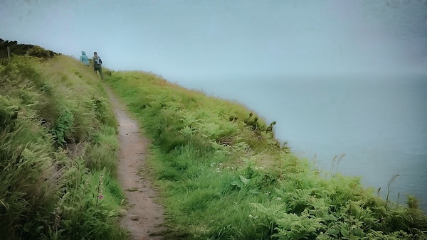
North Head, looking west
North Head, Saltom Bay Views – Coast to Coast
North Head is the northern promontory of St Bees Head, forming a dramatic sandstone cliff that towers above Saltom Bay. Though the Coast to Coast path begins at the foot of South Head, it soon climbs the clifftops and rounds North Head, revealing panoramic views across the Irish Sea. From here, walkers can gaze toward Whitehaven’s rugged coastline, the Isle of Man to the west, and Dumfries and Galloway to the north. The cliffs form part of the Saint Bees Head Heritage Coast, with Fleswick Bay separating North Head from its southern counterpart.
Saltom Bay & Sea Fog Drift
From North Head, the view stretches across Saltom Bay towards Whitehaven, where cliffs and harbour can disappear beneath drifting banks of sea fog even while the clifftops remain bathed in sunshine. Both the towering sandstone cliffs and the waters below form part of nationally protected conservation areas, recognised for their exceptional geological, coastal and marine wildlife.
View to the Isle of Man
From North Head, the Coast to Coast path commands magnificent views across the Irish Sea. On exceptionally clear days, the central mountains of the Isle of Man rise above the western horizon, with Snaefell and Beinn-y-Phott clearly defining the island’s skyline some 30 miles offshore.
Saltom Bay from Sandwith
Looking north from the lanes near Sandwith, the broad sweep of Saltom Bay reveals the rugged outline of North Head, with the former quarry bungalows perched high above the sandstone cliffs. This elevated viewpoint showcases the dramatic scale of the St Bees Head Heritage Coast as it stretches north towards Whitehaven.
View North from North Head
From this lofty perch on North Head, the coastline sweeps northwards in a graceful sandstone arc towards Whitehaven. Green clifftops crown the deep red sea cliffs below, where the Irish Sea breaks across reefs hidden beneath the waves. Peaceful today, these waters have long tested passing mariners, and many ships have met their fate along this dramatic stretch of coast.
🌍 Coastal Insight
Why Does Sea Fog Roll In So Suddenly?
Walkers on St Bees Head are often surprised to find themselves standing in warm sunshine while the sea below disappears beneath a blanket of white fog. This is a form of advection fog, created when warm, moisture-laden air drifts across the much cooler waters of the Irish Sea. As the air cools, the moisture condenses into countless tiny droplets, forming a dense bank of sea fog that can advance across the coast with remarkable speed.
Unlike inland fog, which often develops overnight, sea fog can arrive at almost any time of day. It frequently fills bays and inlets first, leaving the higher clifftops bathed in sunshine while the coastline below disappears from view. A light change in wind direction can then carry the fog ashore within minutes before it melts away just as quickly as the land warms.
For centuries this unpredictable weather made the waters around St Bees Head especially hazardous. Hidden reefs, powerful tides and rapidly falling visibility created dangerous conditions for ships navigating the Cumbrian coast, making the lighthouse and later the foghorn essential aids to safe navigation.
Today the drifting fog remains one of the most memorable sights along the Coast to Coast Walk. It is a reminder that, despite modern forecasting, the Irish Sea still possesses the power to transform the landscape in a matter of minutes.
Coastal Weather at a Glance
Weather Feature: Advection (sea) fog
Forms When: Warm, moist air passes over colder seawater
Most Common: Spring and summer with onshore winds
Effect: Bays may disappear beneath fog while the clifftops remain in sunshine
Clifftop Curve, North Head
From the old sandstone quarry, the Coast to Coast path follows the graceful curve of North Head as the red sandstone cliffs sweep south towards St Bees. Even on quiet days the headland retains its rugged beauty and timeless grandeur. Although the seabird colony has declined from its former abundance, these cliffs remain one of England’s most important nesting sites, where fulmars, guillemots, razorbills and kittiwakes continue to breed each spring.
Braystones Station Watching the Sea
Source: Believed to be in the public domain; original author unknown.
In 1879, the Luigi Olivari was lost off North Head during a snowstorm, her mast light briefly glimpsed from Braystones Station by eleven-year-old John McGill. By morning, wreckage and bodies lay scattered along the shore. Twelve lives were lost: eleven unidentified Italian sailors and Henry Legg, a Cornish pilot. They now rest together in St Bees churchyard, beneath a memorial that is still adorned with seashells. Though the wreck has long since vanished, the headland remembers. North Head, now peaceful, once echoed with the sound of surf and sorrow.
Prehistoric Red Sands North Head
Beneath the towering cliff buttresses of Saltom Bay lie the rich red sands and sandstone that define this remarkable coastline—enduring remnants of a prehistoric desert more than 250 million years old. These Permian and Triassic sandstones owe their vivid colour to iron oxide coating each grain, while tiny flakes of mica catch the light and give the rock its subtle sparkle. Fine, uniform grains also made the stone highly workable, helping establish the sandstone quarry that once operated on North Head.
Hiking the Coast to Coast trail guide
Hiking the Coast to Coast is a digitally enhanced eBook designed to accompany you on your journey along the Coast to Coast path. Available on Apple Books for iPhone, iPad and Mac, the guide includes:
• Mapping with interactive features
• Step-by-step route directions
• Hundreds of colour photographs
• Route conditions in different weather
• Historical and cultural points of interest
Whether you’re planning your trip or already on the trail, it’s a practical and beautifully illustrated resource to carry with you.



