Angle Tarn, Patterdale, Coast to Coast
More Articles in the Patterdale to Haweswater subsection
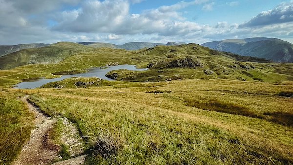
Angle Tarn from Dubhow Brow
Angle Tarn, Boredale - Coast to Coast
Angle Tarn sits on the Coast to Coast route between Rooking, a small hamlet east of Patterdale, and the long ridge path toward Haweswater. It occupies a high plateau above Hartsop, held between the twin Angle Tarn Pikes to the north, Cat Crag to the west, Brock Crags to the south, and Buck Crag to the east. Walkers typically reach the tarn from Rooking via Boredale Hause or by the steeper climb from Hartsop. Angle Tarn is well known for wild camping, fly fishing, and its sweeping views across the upper Ullswater fells.
Angle Tarn Plateau
Angle Tarn occupies a large area atop the plateau between Cat Crag and Heck Crag, just south of the twin Angletarn Pikes. It is fed from gills running down from the Angletarn Pikes. The Tarn's outflow is the Angletarn Beck, located at the Tarn's north west corner.
Angle Tarn Inflows
Angle Tarn has two islands and an isthmus. Its inflow is from two un-named becks coming from the boggy morass between the Angletarn Pikes, and from a gill emanating between Brock Crags and Satura Crag, and from the marshy area to the south of the Tarn.
Angle Tarn Beck Outflow
Angletarn Beck escapes the tarn at its north-west corner, slipping between Dubhow Brow and Cat Crag before tightening into a deepening ravine. As the ground steepens, the beck is pinched between Fall Crag and Lingy Crag, where its waters accelerate toward Dubhow and the confluence with Goldrill Beck. Viewed from above, the outflow is easily recognised by the broad channel beside a small south-shore promontory that edges into the tarn at the foot of the image.
Beck above Hartsop
From the pastures above Hartsop there is a clear view to Dubhow Brow and Cat Crag, with Angletarn Beck emerging sharply from the flank of the Brow. Here the beck slices a narrow gash through the rocks before plunging down the steep valley wall, its course marked by pale ribbons of water on dark stone. The descent continues unbroken until the beck finally merges with Goldrill Beck just north of the village, carrying the tarn’s waters towards Patterdale.
North Angletarn Pike
Approaching from Boredale Hause, the Coast to Coast path swings sharply west at Dubhow Crag, bringing the northern Angletarn Pike into direct view. This is the higher of the twin summits, rising to 567 m and carrying the Wainwright designation. Its rugged crest stands sentinel over Angle Tarn and the surrounding ridges, a prominent landmark guiding walkers towards the upland plateau.
Angletarn Pikes Ridge
From Satura Crag the full sweep of the Angletarn Pikes rises above the tarn, their twin summits casting a broad shadow over the upland bowl below. This angle also reveals the tarn’s inner architecture — the larger of the two islands and the slender isthmus linking the shoreline to its rocky neighbour. It is a classic perspective, showing the Pikes both as guardians of the plateau and as the defining backdrop to Angle Tarn itself.
Angle Tarn from Buck Crag
As the Coast to Coast path skirts the eastern side of Angle Tarn, a glance back from Buck Crag reveals the tarn lying quiet beneath drifting mist. From this height the islands, isthmus and dark waters appear softened and remote, and the ridge seems to retreat into silence. It is a place where the fell feels both expansive and intimate, offering a moment of solitude before the path turns toward Satura Crag and the long traverse to Haweswater.
Take the Coast to Coast Guide With You
Available on Apple Books — £12.99
Hiking the Coast to Coast combines step-by-step route directions, interactive mapping, hundreds of original photographs and information about the landscapes, history and places encountered along the route.
© 2026 Roy McKee · Coast to Coast
Contact - Privacy. - Terms


