Fleswick Bay, St Bees - Coast to Coast
More Articles in the St Bees to Ennerdale Bridge subsection
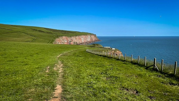
Approach Fleswick Bay from North Head
Fleswick Bay, St Bees - Coast to Coast
Fleswick Bay lies between the North Head and South Head of St Bees Head — the dramatic, ear-shaped promontory of sandstone cliffs that juts into the Irish Sea between St Bees and Whitehaven. This secluded shingle beach offers a rare intertidal platform, exposed at low tide in waveform patterns not seen elsewhere along this stretch of coast. Above the bay is Hannah Moor, while to the north stands St Bees Lighthouse. A spring emerges on the eastern slope, descending from the 75m contour to the 50m line before trickling between the twin headlands onto the pebbled shore below.
Tarnflatt Hall Approach
From Tarnflatt Hall, a peaceful farm track crosses open pasture towards St Bees Lighthouse, offering one of the most scenic approaches to Fleswick Bay. With every step, the landscape becomes wilder as the route leaves the farmland behind and heads towards the towering red cliffs of the Heritage Coast.
Tarnflatt Garden Path
Lush hedgerows and vibrant seasonal flowers line the approach to Tarnflatt Hall, providing a colourful prelude to the walk ahead. Beyond these peaceful gardens, the path soon leaves the shelter of the countryside for the windswept cliffs and sweeping coastal views of Fleswick Bay.
St Bees Lighthouse
Perched high above the Irish Sea, St Bees Lighthouse marks the northern headland overlooking Fleswick Bay. From this commanding viewpoint, the Coast to Coast path curves around the magnificent red sandstone cliffs before continuing north towards Saltom Bay, one of the most spectacular stretches of the Cumbrian coast.
Cloven Barth Pinnacle
Cloven Barth stands proudly beside the towering cliffs of St Bees Head, isolated from the mainland by a deep sandstone cleft created by centuries of coastal erosion. Also known as Lawson’s Leap, this striking sea stack combines dramatic geology, local folklore and one of the finest viewpoints for watching the seabirds that nest along the Heritage Coast.
Fleswick Bay
Descending from North Head, the wooden cliff steps reveal one of the finest coastal panoramas on the Coast to Coast Walk. Across the secluded shingle bay, the towering red sandstone cliffs of South Head rise above the Irish Sea, their hidden coves and difficult access once making this a discreet landing place for smugglers along the Cumbrian coast.
Wreck of the Izaro (1907)
Historic England Research Records
This remarkable photograph records the wreck of the Spanish steamship Izaro, driven onto the rocks at Fleswick Bay during a fierce storm in 1907. The towering sandstone cliffs provide a dramatic backdrop to one of the best-documented maritime disasters on the St Bees coast, reminding visitors that these beautiful headlands have long inspired both admiration and respect.
North and South Heads Divide
The deep gully of Fleswick Bay separates the towering headlands of North Head and South Head, creating one of the most striking landforms along the St Bees coast. Steep paths descend from either side to the secluded shore below, where the dramatic cliffs reveal the immense power of the sea to shape the landscape over millions of years. The southern headland, known locally as The Tomlin, has long been associated with shipwrecks and coastal folklore.
Fleswick Beck Gutter
Fleswick Beck has carved a deep gully between the towering headlands of North Head and South Head, creating one of the most striking features along the St Bees Heritage Coast. Steep paths descend from either side to the secluded shingle shore, where the combined forces of running water and the Irish Sea continue to shape the cliffs today.
Red Sandstone Cliffs
The magnificent red sandstone cliffs of Fleswick Bay display the warm colours of the St Bees Sandstone Formation, laid down by braided rivers over 250 million years ago. Continual erosion by weather and the sea slowly reshapes these towering cliffs, creating the dramatic coastline seen today.
🪨 Geology Insight
Why Are the Cliffs of St Bees So Red?
The spectacular cliffs of St Bees Head belong to the St Bees Sandstone Formation, a sequence of rocks laid down around 250 million years ago during the Triassic Period. At that time, Cumbria lay within a vast desert crossed by wide, braided rivers that carried sand and gravel across an arid landscape.
As these sediments accumulated, minerals containing iron slowly oxidised in the hot, oxygen-rich environment, coating the sand grains with iron oxide — the same natural process that produces rust. This gives the cliffs their distinctive deep red and orange colours, making them one of Britain’s most recognisable coastal landscapes.
Today, the Irish Sea and the weather continue to erode these comparatively soft sandstones, steadily reshaping the cliffs and supplying fresh material to the beaches below.
Standing beneath these towering cliffs, walkers are looking at the remains of an ancient desert, while witnessing a coastline that is still evolving under the relentless forces of wind, rain and sea.
Geological Age: Triassic Period (c. 250 million years ago)
Rock Type: St Bees Sandstone
Landscape Feature: Coastal sea cliffs
Sea Campion Clifftop Cluster
Clinging to the windswept cliffs of Fleswick Bay, Sea Campion produces clusters of delicate white flowers above the red sandstone headland. Perfectly adapted to this harsh coastal environment, it blooms alongside thrift, gorse and scurvy grass, softening the rugged cliffs with unexpected colour.
Cornflower Blue Gully Bloom
A vivid cornflower brings a splash of brilliant blue to the grassy gully between North and South Head. Sheltered from the strongest coastal winds, this quiet hollow supports a rich variety of wildflowers, creating a colourful haven for pollinating insects against the dramatic backdrop of the St Bees cliffs.
Hiking the Coast to Coast trail guide
Hiking the Coast to Coast is a digitally enhanced eBook designed to accompany you on your journey along the Coast to Coast path. Available on Apple Books for iPhone, iPad and Mac, the guide includes:
• Mapping with interactive features
• Step-by-step route directions
• Hundreds of colour photographs
• Route conditions in different weather
• Historical and cultural points of interest
Whether you’re planning your trip or already on the trail, it’s a practical and beautifully illustrated resource to carry with you.



