Heritage Coast, St Bees, Coast to Coast
More Articles in the St Bees to Ennerdale Bridge subsection
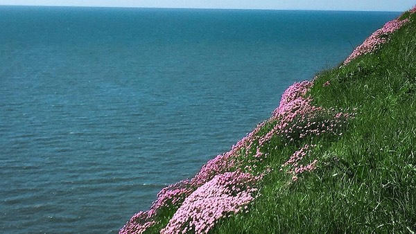
Thrift (Sea Pink) on South Head, St Bees
Seabirds, Sea Cliffs, and St Bees’ Living Edge
The Heritage Coast at St Bees Head marks the only stretch of undisturbed sea cliffs along the entire Cumbrian coastline, and forms part of a designated Site of Special Scientific Interest (SSSI). This dramatic headland includes both the North Head and South Head cliffs, which rise steeply from the Irish Sea and host dense colonies of nesting seabirds — including guillemots, kittiwakes, razorbills, and fulmars. A series of wooden viewing platforms allow walkers to pause and observe these thrumming ledges of maritime life, perched against the wind-scoured bluff faces.
The North Head is also an RSPB reserve, and lies just beyond the coastal edge of St Bees village, home to the historic St Bees Priory and the remarkable story of St Bees Man. The cliffs here are crowned by the St Bees Lighthouse — a striking white tower still in operation today — before the protected coastline stretches eastward along Saltom Bay, forming part of the Cumbria Coast Marine Conservation Zone. The path along the cliff edge is the official starting point of the Coast to Coast Walk, and offers one of the most striking seaward views in northern England.
Cumbria Coast MCZ, St Bees Bay
From the summit of South Head, the panorama stretches across St Bees Bay, the village and the sweeping red sandstone cliffs that form Cumbria’s only Heritage Coast. Beyond the cliff edge lies the Cumbria Coast Marine Conservation Zone, designated in 2013 and extending for approximately 27 kilometres from south of Whitehaven to the Ravenglass Estuary. Its protected waters and intertidal habitats, from rocky scars and honeycomb worm reefs to shifting sands, support an extraordinary diversity of marine life beneath the waves.
Whitriggs Scar Cumbria MCZ
From Seascale, the view looks north across a broad tidal channel winding through the coastal marshes towards Ravenglass, with a solitary pipeline spanning the water between the two shores. Beyond lies the southern end of the Cumbria Coast Marine Conservation Zone, where the boulder reefs and cobbled scars of Whitriggs Scar provide a rich marine habitat. Farther south, Barn Scar and Kokoarrah Rocks support nationally important honeycomb worm reefs, whose remarkable sand-built structures are revealed and concealed with each passing tide, creating shelter for a wealth of marine life.
RSPB Viewing Platforms St Bees
Perched high on the cliffs of St Bees Head, two RSPB viewing platforms provide some of the finest vantage points for observing Cumbria’s only breeding seabird colony. The platform shown here overlooks Fleswick Bay, while the second stands further north near Cloven Barth. From both, visitors can watch thousands of seabirds crowding the narrow cliff ledges, circling effortlessly on the sea breeze or resting on the waters below, their constant calls carrying across the Heritage Coast throughout the breeding season.
Guillemots on the Ledges
From the RSPB viewing platforms, the towering cliffs reveal one of England’s finest seabird spectacles. Thousands of guillemots, kittiwakes, fulmars and razorbills crowd the narrow rock ledges, nesting shoulder to shoulder with scarcely a gap between them. At first glance, guillemots are easily confused with razorbills, but they have slimmer, more pointed bills and chocolate-brown upperparts, rather than the razorbill’s glossy black plumage and deep, flattened bill. During the breeding season, the cliffs are filled with the constant movement and calls of these remarkable seabirds as they return from the Irish Sea to breed on the cliff ledges.
Heritage Coast Saltom Bay
St Bees from Whitehaven
The Cumbria Heritage Coast presently encompasses all of St Bees Head and extends out to sea — the only stretch of Heritage Coast between Wales and Scotland. In 2016, the National Trust proposed a northern extension toward Whitehaven, and following a public consultation in 2019, the plan was broadly supported. Parts of the expanded area, including land near Kells Farmland, are now under review for formal adoption. This image, taken from the cliffs above Whitehaven, looks south across Saltom Bay toward the red sandstone ramparts of St Bees Head.
SSSI Cliffs, St Bees Head
From the clifftop, the view plunges to the rocks and restless Irish Sea far below, where the red sandstone cliffs meet the water in dramatic fashion. These towering cliffs form part of the St Bees Head Site of Special Scientific Interest (SSSI), designated for both their geological importance and exceptional wildlife. They support the only breeding colony of cliff-nesting seabirds in north-west England, protected as an RSPB reserve, where thousands of guillemots, razorbills, kittiwakes, fulmars and herring gulls return each spring to raise their young before dispersing once more across the open sea.
Cumbria Coastal Way - South Head
The Cumbria Coastal Way once marked a continuous 182-mile path from Silverdale to Carlisle, though it’s now largely unmarked and not officially maintained. Its route survives in places—but its legacy continues under the banner of the King Charles III England Coast Path, the new National Trail aiming to encircle England’s coastline with a continuous walking route. At present, multiple sections of the Trail are open, but it is not yet fully completed . This view, taken from the Coast to Coast path above South Head, looks south toward Sellafield — a landscape shaped by industry, erosion, and walking traditions old and new.
Coast to Coast Path
Here, on the foreshore at St Bees beneath the red sandstone cliffs of South Head, Alfred Wainwright’s celebrated Coast to Coast Walk begins. Marked by a commemorative plaque set into the stone, the route follows the cliff tops of the Heritage Coast before turning inland towards Sandwith and the mountains of the Lake District. Over the next 190 miles it crosses three of England’s finest national parks—the Lake District, the Yorkshire Dales and the North York Moors—before ending on the shores of Robin Hood’s Bay, linking two seas through an ever-changing journey of mountains, valleys, moorland and coastline.
Hiking the Coast to Coast trail guide
Hiking the Coast to Coast is a digitally enhanced eBook designed to accompany you on your journey along the Coast to Coast path. Available on Apple Books for iPhone, iPad and Mac, the guide includes:
• Mapping with interactive features
• Step-by-step route directions
• Hundreds of colour photographs
• Route conditions in different weather
• Historical and cultural points of interest
Whether you’re planning your trip or already on the trail, it’s a practical and beautifully illustrated resource to carry with you.



