Wain Wath Force, Keld, Coast to Coast
More Articles in the Kirkby Stephen to Keld subsection
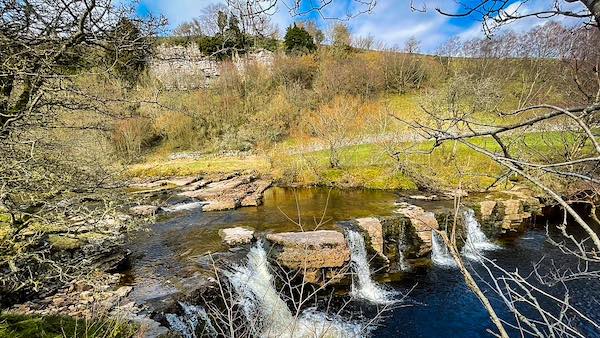
Wain Wath Force, River Swale, Keld
Wain Wath Force, Keld, Coast to Coast
Wain Wath Force is a wide and resplendent waterfall located on the River Swale, 3/4 mile west of the Swaledale hamlet of Keld and 200 yards east of Park Bridge at Silver Hill. Between the waterfall and the road is a large smooth, broad grassy tract used for picnics and sunbathing by wild swimmers. On the opposite bank is Cotterby Scar, a sprawling band of dappled white limestone stretching from Low Bridge to the waterfall.
Wain Wath Force
Force is a modern term for the word fosse, which is the old Norse word for waterfall. Wain means cart and wath is the Anglo Saxon word for a ford. So Wain Wath Force means a waterfall beside a cart ford. The Swale broadens out just east of the Force so it is possible there was once a ford there.
Wain Wath Force
Wain Wath Force is visible from the Keld Road, heading east, after passing Park Bridge. Although the drop is insignificant the width of the Fall creates a magnificent view along the Swale.
Wain Wath Force River Swale
Stationed at Park Bridge and looking west along the River Swale, Wain Wath Force and a number of smaller, nearer cascades, can be seen, beyond which is the long band of Cotterby Scar.
Park Bridge and Park House
The Coast to Coast path follows the River Swale along its north bank, below Cotterby Scar, and after joining Stonesdale Lane the path crosses the bridge and proceeds to Keld along the B6270. Park House has a bunk house and a yurt campsite on the east side of the bridge.
Cotterby Scar
Cotterby Scar is a long band of limestone cliffs making up the south face of West Stonesdale Out Pasture. Below the scar is the River Swale and Wain Wath Force.
Coast to Coast Trail Guide
Hiking the Coast to Coast
"Hiking the Coast to Coast" is a digitally enhanced eBook available from Apple Books for all people who have either a Mac, an iPhone or an iPad, and is designed to accompany you on your walk of the Coast to Coast path. The trail guide contains Ordnance Survey maps and other advanced mapping features, step by step directions, hundreds of colour photographs, details of the route, its conditions in different weather and research snippets relating to places of interest along the way.
