The Hills, Great Fryup Dale, Glaisdale
Historical and Educational Articles for Lion Inn to Grosmont
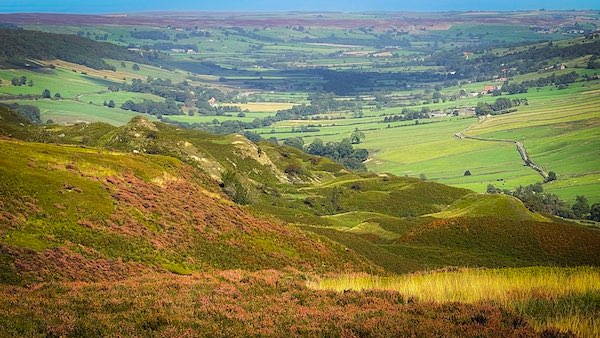
Approaching The Hills from the Coast to Coast path. Great Fryup Dale beyond
The Hills, Great Fryup Dale, Glaisdale Coast to Coast
The Hills is part of the valley head of Great Fryup Dale. It occupies the west valley wall of the dale head, climbing from the valley floor to the bleak moorland of Glaisdale. Trough House and the Coast to Coast path are a quarter mile south, and to the west are Danby Rigg and Castleton Rigg.
It was not until 1891 that the public at large became aware of just how unique and wonderful this section of the dale head was. This was thanks to John Christopher Atkinson, a graduate of Cambridge University and Fellow of Trinity Hall, Cambridge. In 1891 he was the Vicar of Danby, and In order to better understand and friendship his parishioners he set about learning all he could about the parish in which he presided. This involved him learning all he could about local customs and legends, and in order to share his knowledge he wrote a book entitled "Forty Years in a Moorland Parish", the book for which he is best known. Although he wrote many other publications, it was this book he was best known for.
The Hills has been created from a series of undercliffs on the west valley wall, caused by the wave action of a great glacial lake that once occupied Great Fryup Dale, Little Fryup Dale and the River Esk Valley. A detailed study of this area by Holiday and others in 1992 has found ample evidence of successive high density, deep-seated relict landslides, accounting for the unique terrain of The Hills. In other words, wave erosion from the glacial water has undercut the cliff face resulting in successive landslides.
Fryup Trough Great Fryup Dale
When walking east along the Coast to Coast path on the Cut Road, the first physical feature of The Hills is Fryup Trough. The is actually the head of Great Fryup Dale, looking down towards the valley floor between Trough Gill Beck and George Gap Causeway.
The Scar above "The Hills"
The Scar is an exposed outcrop of rock that follows the 350m contour above The Hills, dropping from the moorland to the hummocky undulations about 20m below. The Scar has a near vertical drop. The bedrock of The Scar is made from a mixture of sedimentary rocks comprising mudstone, silstone and sandstone, although there are subsidiary ironstone and limestone beds.
Oven Mouth to Mark Nab
The undercliff progresses northwards along the Dale Head and is more pronounced from the area defined as Oven Mouth. This is where there is an eastwards kink in The Scar which is flagged by an east extending boundary wall and a wooded tributory to the Trough Gill Beck and valley floor. The north west corner of The Scar is Mark Nab.
The Hills Landslide Layers
"The Hills" is a much studied Undercliff and comprises layers of landslide deposits produced by the continual undercutting of the west valley wall. This occured during the Pleistocene Ice Age, as the continuous wave action of Great Fryup Dale's glacial lake gradually cut into the mudstone cliff.
Mark Nab Landslides
The landslide deposits further north below Mark Nab, which are centered around the 300m contour, have a different appearance to those nearer the Dale Head. In the background is Fryup Heads, a large central mass that sunders the valley entrance, producing the twin valleys of Great Fryup Dale and Little Fryup Dale.
Mark Nab with The Hills below
Mark Nab is the stubby cliff face projecting from the south east face of Danby Moor into Great Fryup Dale. It falls steeply to The Hills, a large area where the submarine wave action of a glacial lake has caused repeated landslides of the Moorland's edge. The image is taken from Fryup Hall Farm and shows the view from the north in contrast to the prior views taken from the south.
Dale Head Waterfalls
The Coast to Coast path sweeps over the top of Dale Head and the might of the eminent waterfalls is unseen. However, from Fryup Hall Farm the Head of the Dale is easily picked out, and the two most prominent waterfalls are comfortably identified. On the west side of Dale Head (right) is Trough Gill Beck; to the east of the Beck is Yew Grain which clearly shows two drops as it plummets over Yew Grain Scar. Both Falls are in spate due to the melting snow on the moorland plateau.
George Gap Causeway
The Coast to Coast path follows across the top of the back wall of Great Fryup Dale. It is bisected by George Gap Causeway, a path that commences at Dale Head Farm in the Farndale Valley, connecting it to Great Fryup Dale. It descends the backwall passing over Yew Grain Scar and continues along the foot of The Hills to reach Wood End Farm.
Coast to Coast Trail Guide
Hiking the Coast to Coast
"Hiking the Coast to Coast" is a digitally enhanced eBook available from Apple Books for all people who have either a Mac, an iPhone or an iPad, and is designed to accompany you on your walk of the Coast to Coast path. The trail guide contains Ordnance Survey maps and other advanced mapping features, step by step directions, hundreds of colour photographs, details of the route, its conditions in different weather and research snippets relating to places of interest along the way.
