Castlehowe Stone Circle, Hardendale
More Articles in the Haweswater to Orton subsection
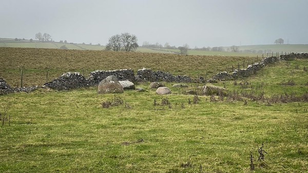
Castlehowe Stone Circle near Hardendale
Castlehowe Stone Circle, Hardendale, Coast to Coast
The minor road from Shap to Crosby Ravensworth passes through a landscape rich in prehistoric remains, with stone circles, erratics and early settlements scattered across the surrounding fields. This quiet corridor of the eastern Lake District fringe preserves clear evidence of sustained Neolithic and Bronze Age activity.
Castlehowe Stone Circle is one such monument, located just north of Hardendale in a field south of the Shap road. Its position is easily recognised by the young deciduous woodland on Castlehouse Scar, a former quarry that extends from the roadside towards Hardendale Quarry Lake. The circle itself lies in the south-east corner of a small field immediately west of the plantation, set quietly within this wider archaeological landscape.
Castlehowe Stone Circle
Castlehowe Stone Circle is a compact Bronze Age monument formed of ten pink Shap granite boulders and a single contrasting blue stone. Measuring approximately 5 metres in diameter, the circle sits quietly in the south-east corner of a rough grass field beneath Castlehouse Scar. Despite its modest scale, it is a designated scheduled monument, recognised by Historic England for its archaeological importance within this richly prehistoric landscape.
Castlehouse Scar Woodland
Castlehouse Scar lies just yards from the stone circle, separated only by a bridleway and a low stone wall. Once a working quarry, the scar has since been re-landscaped and planted with young deciduous woodland, softening its industrial past. The emerging trees now frame the field edge and circle beyond, creating a subtle contrast between prehistoric settlement and more recent human alteration of the land.
Hiking the Coast to Coast trail guide
Hiking the Coast to Coast is a digitally enhanced eBook designed to accompany you on your journey along the Coast to Coast path. Available on Apple Books for iPhone, iPad and Mac, the guide includes:
• Mapping with interactive features
• Step-by-step route directions
• Hundreds of colour photographs
• Route conditions in different weather
• Historical and cultural points of interest
Whether you’re planning your trip or already on the trail, it’s a practical and beautifully illustrated resource to carry with you.


