Hardendale Nab, Oddendale, Shap
More Articles in the Haweswater to Orton subsection
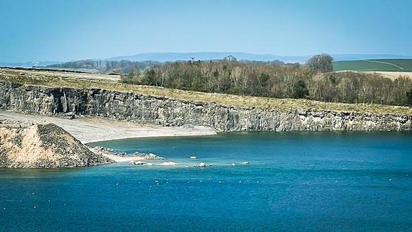
Hardendale Quarry Lake
Hardendale Nab, Oddendale - Coast to Coast
Hardendale Nab is a modest limestone rise reaching 370 metres, situated between Oddendale to the south east and the village of Shap to the north west, close to the line of the M6. Its eastern flank is defined by the workings of Hardendale Quarry, while the Coast to Coast path crosses the quieter southern slopes of Hardendale Nab, offering a transition between open fell and worked landscape. Parts of the quarry margins have already been restored, and further proposals are in place to reshape the land around Hardendale Quarry lake, including the creation of a protective bund and hibernacula to encourage amphibian habitats alongside the existing pools.
Nab Farm Hardendale Nab
The Coast to Coast path begins its ascent of Hardendale Nab after crossing the M6, climbing steadily along the lower slopes above the valley floor. It passes to the south of The Nab farm before crossing a quiet minor road, from where the route continues across open ground toward the limestone scars and the twin quarry ponds that mark the eastern side of the Nab.
Hardendale Nab Coast to Coast
The Coast to Coast path crosses the B6261 in open moorland on the western side of Hardendale Nab, with the line of the M6 running only a short distance to the east, already passed on the approach from Shap. From here the route continues across the lower slopes of the Nab, crossing the quarry access road before skirting above Oddendale on its way towards Crosby Ravensworth Fell.
Hardendale Nab South Face
From the quarry pools below Nell’s Moss, the south-facing slopes of Hardendale Nab rise gently towards the 370-metre summit, with an arc of rainbow light briefly spanning the valley. Beyond, the limestone scarps are more clearly defined on the opposite, northern face of the Nab, where the underlying rock is exposed along the higher ground.
Hardendale Nab Summit
From the summit of Hardendale Nab, the ground levels into a broad crest, where a glance to the north reveals an arcing band of low, crumbling limestone scarps. Along the flat summit top, a faint rainbow traces a similar curve across the skyline, echoing the natural arc of the exposed rock below.
Hardendale Nab Limestone Scarps
A short distance north of the 370-metre summit, a curved band of low limestone scarps follows the 360-metre contour, sweeping from south towards the north-east. These broken cliffs provide a natural bield for sheep, with the turf dipping gently at their base to create additional shelter. The ground bears quiet evidence of long use, with scattered remains and occasional skulls lying among the rocks.
Limestone Grikes Hardendale
The limestone pavement above the scarps is cut by numerous grikes—deep, narrow fissures formed by weathering along natural joints in the rock. These shaded clefts draw the eye of passing walkers, their irregular depths and hidden edges adding both interest and caution to the crossing.
Common Land Hardendale Nab
Hardendale Nab lies within an area of registered common land, with ownership held by Shapfell Limestone Ltd. The company retains a limited proprietary interest—known in law as a profit à prendre in gross—while grazing rights are exercised by local commoners, most visibly through the presence of sheep across the fell.
Cairn Towers Hardendale Nab
Immediately north of the curved limestone scarps, a line of well-built cairn towers stands along the crest of Hardendale Nab. Formed from locally gathered stone, these exposed markers follow the higher ground, creating a striking and unexpected feature above the cliffs.
Sandpot Hole Hardendale Lake
Ordnance Survey mapping marks a small pool known as Sandpot Hole near the edge of the Castlehouse Scar plantation, close to the Oddendale road. The feature now lies beneath the waters of Hardendale Quarry Lake, having been lost to the expansion of the workings, with no visible trace remaining on the surface.
Hardendale Nab and Quarry Lake
A footpath from Shap skirts the northern edge of Hardendale Nab before reaching the Oddendale road near the quarry lake. From here, the road can be followed along the eastern shore, where open views extend across the water towards the rising slopes of the Nab.
Hardendale Lake Restoration
As restoration progresses, Hardendale Quarry Lake is set to become a managed habitat for wildlife. Local plans include a circular footpath around the lake, additional tree planting, and the creation of a bund and hibernaculum to support amphibians and reptiles. These features provide sheltered basking areas and protected spaces for overwintering within the restored landscape.
Hardendale Nab from Seal Howe
Looking back from the Coast to Coast path near Seal Howe, the hamlet of Oddendale appears clustered within a protective shelterbelt of trees, a welcome feature in this exposed moorland setting. Beyond, Hardendale Nab rises to the north-west, its form readily identified by the quarry workings cut into its eastern flank.
Hiking the Coast to Coast trail guide
Hiking the Coast to Coast is a digitally enhanced eBook designed to accompany you on your journey along the Coast to Coast path. Available on Apple Books for iPhone, iPad and Mac, the guide includes:
• Mapping with interactive features
• Step-by-step route directions
• Hundreds of colour photographs
• Route conditions in different weather
• Historical and cultural points of interest
Whether you’re planning your trip or already on the trail, it’s a practical and beautifully illustrated resource to carry with you.



