Sunbiggin Tarn and Cow Dub, Tarn Moor
More Articles in the Orton to Kirkby Stephen subsection
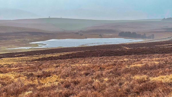
Sunbiggin Tarn from the top of Tarn Moor
Sunbiggin Tarn, Tarn Moor - Coast to Coast
Sunbiggin Tarn lies among the quiet grasslands of Tarn Moor, about a mile east of the tiny hamlet of Sunbiggin, 3 east of Orton, and between the limestone country of Great Asby Scar and the upper Lune Valley. At first sight it appears to be simply a small sheet of open water beside the moorland road, but the tarn is only the visible centre of a much larger and remarkably rich wetland.
Reeds, rushes and sedges spread far beyond the open water, merging into marshy ground and the surrounding limestone grassland. To the south, a narrow channel connects Sunbiggin Tarn with the smaller Cow Dub, whose waters eventually drain away through Tarn Sike. Together they form part of an intricate landscape of tarns, springs, flushes and wetlands scattered across Tarn Moor.
The apparent emptiness of the moor disguises its extraordinary natural history. The tarn and surrounding wetlands support breeding and visiting birds, while the lime-rich ground creates specialised habitats for plants and tiny creatures that survive in remarkably few places elsewhere in Britain. For the Coast to Coast walker, Sunbiggin Tarn is therefore much more than a quiet roadside pool — it is the visible heart of one of the most distinctive wetland landscapes along this part of the route.
Sunbiggin Tarn
Sunbiggin Tarn lies beside the lonely moorland road crossing Tarn Moor between Raisbeck and Great Asby. From here it appears a modest sheet of open water, but the photograph only hints at its true extent. Beyond the visible shoreline, reeds and wetland vegetation spread into the surrounding grassland, forming part of the nationally important Sunbiggin Tarn and Moors SSSI. The tarn and its wetlands provide valuable habitat for breeding and visiting birds, while to the south a narrow channel links the water with Cow Dub. What first appears to be an isolated pool is really the heart of a much larger and remarkably rich wetland landscape.
The Reedy Waters of Sunbiggin Tarn
Around the margins of Sunbiggin Tarn, open water gradually gives way to a dense mosaic of reeds, rushes and sedges. What looks like solid ground can remain saturated beneath the vegetation, while channels and pockets of water survive between the plants. This is a landscape in slow transition, as vegetation traps sediment and organic matter and the wetland gradually becomes shallower. The change is almost imperceptible from year to year, but over time the boundary between tarn and moor steadily shifts — nature quietly redrawing the shoreline.
Sunbiggin Tarn
From the higher ground near Howes Well, Sunbiggin Tarn reveals a very different character. Open water occupies only part of the shallow basin; beyond it, broad margins of reeds, rushes and wetland vegetation spread into the surrounding moor. From this elevated viewpoint the gradual transformation is much easier to read, as water gives way almost imperceptibly to marsh and grassland. What appears from the roadside to be a simple tarn becomes, from above, a living mosaic of water and wetland — a landscape slowly changing before our eyes.
🐌 Insight - Natural History
The Sandbowl Snail
To the walker, the wet ground surrounding Sunbiggin Tarn may appear to be little more than rushes, mud and shallow pools. Yet hidden within these lime-rich wetlands lives one of Britain’s rarest and most easily overlooked molluscs — the sandbowl snail (Catinella arenaria).
Its shell is only around 5–8 mm high, reddish-amber in colour and frequently coated with mud, making the animal remarkably difficult to see against the ground on which it lives. In Cumbria it occupies a very specialised habitat: exposed wet mud within calcareous flushes and wet meadows, where mineral-rich water emerges through the limestone landscape.
This explains why apparently insignificant patches of wet ground around Sunbiggin can be so important. The snail does not simply need water; it depends upon a particular combination of lime-rich seepage, permanently damp ground and areas of relatively open vegetation.
The sandbowl snail has an extraordinary British distribution. In Devon it survives in wet hollows among coastal sand dunes, while its Cumbrian populations occupy an entirely different-looking landscape — upland calcareous flushes between Orton and Kirkby Stephen. Historic conservation assessments identified Sunbiggin Tarn as one of only a handful of British strongholds.
Its survival depends upon keeping these tiny wetlands intact. Drainage can remove the permanently damp conditions it requires, while excessive trampling can damage the exposed muddy habitat. Conversely, if vegetation becomes too dense, the open ground on which the snail depends can also disappear.
There is something rather wonderful about that contrast. Sunbiggin Tarn is obvious from the road, but one of its most remarkable inhabitants could rest unnoticed beneath the vegetation at a walker’s feet. What looks like an ordinary patch of wet limestone moorland is, for this tiny creature, an exceptionally rare world.
At a Glance
Species: Sandbowl snail (Catinella arenaria)
Shell: About 5–8 mm high
Colour: Reddish amber, often mud-coated
Cumbrian habitat: Calcareous flushes and wet meadows
Needs: Damp, lime-rich ground with open muddy areas
British distribution: Exceptionally restricted
Sunbiggin: Long-recognised British stronghold
Threats: Drainage, trampling and habitat change
Cow Dub
South of Sunbiggin Tarn lies the smaller and quieter Cow Dub, occupying another shallow hollow in Tarn Moor. Reeds and rushes crowd its margins and spread into the surrounding wet grassland, leaving only a modest area of open water. Yet Cow Dub is not an isolated pool: it belongs to the same intricate wetland system as its larger neighbour. From here the water begins another stage of its journey, eventually escaping through Tarn Sike. Small and easily overlooked beside Sunbiggin Tarn, Cow Dub is another reminder that across Tarn Moor, water is never very far beneath the landscape.
Tarn Sike, Tarn and Grimes Moor
Leaving Cow Dub, Tarn Sike slips quietly away across Tarn Moor, carrying water from the wetlands towards the River Lune. At times little more than a narrow thread through the grass, its course is often easier to follow by the darker rushes and wetter ground along its banks. Behind it lie the open waters of Cow Dub and Sunbiggin Tarn; ahead, the beck becomes part of the wider drainage of the Lune Valley. It is a gentle ending to the story of these tarns — the still water of Tarn Moor finally finding a way through the landscape.
Hiking the Coast to Coast trail guide
Hiking the Coast to Coast is a digitally enhanced eBook designed to accompany you on your journey along the Coast to Coast path. Available on Apple Books for iPhone, iPad and Mac, the guide includes:
• Mapping with interactive features
• Step-by-step route directions
• Hundreds of colour photographs
• Route conditions in different weather
• Historical and cultural points of interest
Whether you’re planning your trip or already on the trail, it’s a practical and beautifully illustrated resource to carry with you.



