Haweswater, Mardale, Coast to Coast
More Articles in the Patterdale to Haweswater subsection
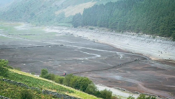
Haweswater 2021, only 40% full following long period without rain
Haweswater, Mardale, Coast to Coast
Haweswater is one of the Lake District’s largest and most dramatic lakes, occupying a long glacial trench beneath the steep eastern flanks of the Far Eastern Fells. A substantial network of becks and tarns drains into it, including Blea Water and Small Water from the High Street ridge, together with Riggindale Beck, Randale Beck, Whelter Beck, Measand Beck, Guerness Gill, Rowantreethwaite Beck and Gatesgarth Beck. Its outflow, Haweswater Beck, carries water northwards before plunging over Thornthwaite Force, one of the valley’s best-known waterfalls.
Although Haweswater appears natural, it is now a managed reservoir. Until the early 20th century it was a smaller, shallower lake, shaped by glaciation and edged by pasture, woodland and two long-established farming communities. In 1929, a private Act of Parliament granted Manchester Corporation permission to dam the lake and raise its water level, transforming it into a reservoir supplying water to Manchester and the surrounding industrial towns. The decision provoked widespread public opposition, as Haweswater was already regarded as one of the Lake District’s finest landscapes.
The creation of the reservoir required the evacuation and flooding of two villages: Measand and Mardale Green. Before inundation, the lake measured approximately 2.5 miles in length. After damming, it extended to around 3.7 miles. A low spit of land near Measand had once partially divided the lake into two distinct reaches, traditionally known as High Water and Low Water, giving Haweswater a more complex and intimate character than it has today.
At full capacity, Haweswater now holds up to 84 billion litres of water. During prolonged dry periods, the submerged past re-emerges: stone field walls, lane alignments, bridge abutments and building foundations appear along the margins, offering a stark reminder of the valley’s former life. For walkers on the Coast to Coast route, Haweswater is not only a striking landscape feature, but also a place where geology, engineering, and social history are inseparably entwined.
Haweswater from Kidsty Howes
The first sight of Haweswater from Kidsty Pike or Kidsty Howes is one of the most anticipated moments on the Coast to Coast path. After long miles across the High Street plateau, the lake appears calm and expansive below, signalling the approach of warmth, shelter, and rest at Mardale Head.
Bowderthwaite at Haweswater
Gate Crag on the south-west shore of Haweswater is scored by farm walls and lanes that descend directly into the lake. These submerged boundaries mark the former fields of Bowderthwaite and are a stark reminder of the deliberate flooding of the valley following completion of the dam in 1935.
Haweswater South Shore
From The Rigg, where the Coast to Coast path crosses the lake’s southern flank, there is a sweeping view over Gate Crag and Speaking Crag toward the Whelter Beck valleys. The ridge rising behind forms the long, broken spine of Dudderwick.
Glacial Geography at Haweswater
Glacial Trough (U-Shaped Valley)
Haweswater occupies a classic glacial trough carved by a powerful trunk glacier flowing eastwards during the last Ice Age.
Overdeepening
The valley floor was eroded far below its pre-glacial level, creating a deep rock basin later filled by water.
Truncated Spurs
The steep, blunt-ended valley sides reveal where interlocking spurs were cut off by moving ice.
Hanging Valleys
Tributary valleys such as those holding Small Water and Blea Water were left suspended above the main trough as the trunk glacier deepened Haweswater more aggressively.
Rock Basin Reservoir
The modern reservoir enlarges what was once a natural lake occupying the glacial rock basin.
Submerged Landscape
When water levels fall, remnants of the old village of Mardale and the original valley floor re-emerge, revealing the true shape of the pre-reservoir landscape.
Wood Howe Haweswater
During the dry autumn of 2021, Haweswater fell to unusually low levels and Wood Howe — normally an island — became accessible on foot. As the waters retreated, the foundations of drowned buildings and old road lines emerged, with Whelter Bottom clearly visible beyond.
The Rigg and Dudderwick
The pale mudflats of an exceptionally low Haweswater contrast sharply with the dark conifer plantations on The Rigg. A path climbs from here onto the Dudderwick ridge, passing Swine Crag, Heron Crag and Eagle Crag before continuing toward High Street.
Swine Crag Dudderwick
The Dudderwick ridge can be gained directly from the lakeshore near Mardale Head. Swine Crag is the first rocky step on the ascent, lying between the 350 and 400 metre contours. In periods of low water, the former fields and walls of Mardale Green are exposed below.
Mardale ill Bell
Below the Dudderwick ridge, the drained southern channel of Haweswater stretches toward Mardale Ill Bell, which dominates the head of the valley. Despite the reservoir’s depleted state, Blea Water and Small Water continue to spill vigorously toward the lake in cascades and falls.
Dried Haweswater Mardale Green
The exposed fields of the former village of Mardale Green merge tonally with the slopes of Dudderwick beyond. Before inundation, the hamlet contained twelve houses, a church, school, and the Dun Bull Inn. More than one hundred residents were displaced, and the buildings were demolished by Royal Engineers.
Haweswater and Four Stones Hill
Midway along the northern shore, Mile Crags rise modestly above the lakeside. Above them stands Four Stones Hill at 415 metres, named for its prehistoric standing stones. Two remain upright near the summit, while the others lie fallen further downslope.
Wallow Crag Haweswater
Wallow Crag is a Wainwright Outlying Fell rising steeply above the south-east shore of Haweswater. Its broken faces shed wide scree fans, and the crag’s abrupt drop to the lake gives it a strikingly austere profile when viewed from across the water.
Haweswater Dam
Looking north-east from Measand End, the dam at Burnbanks spans the narrowed end of Haweswater. Beyond it, Haweswater Beck carries the lake’s outflow eastward, closely followed by the Coast to Coast path toward Rosgill.
Hiking the Coast to Coast trail guide
Hiking the Coast to Coast is a digitally enhanced eBook designed to accompany you on your journey along the Coast to Coast path. Available on Apple Books for iPhone, iPad and Mac, the guide includes:
• Mapping with interactive features
• Step-by-step route directions
• Hundreds of colour photographs
• Route conditions in different weather
• Historical and cultural points of interest
Whether you’re planning your trip or already on the trail, it’s a practical and beautifully illustrated resource to carry with you.



