Hardendale Hamlet, Shap - Coast to Coast
More Articles in the Haweswater to Orton subsection
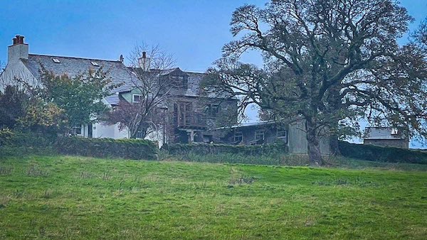
Cluster of Farmhouses in Hardendale
Hardendale Hamlet, Shap - Coast to Coast
The small hamlet of Hardendale is a quiet farming settlement lying approximately 1¼ miles east of Shap and the M6 motorway, set within a shallow valley beneath the rising slopes of Hardendale Nab. At its centre stands Hardendale Hall, a Grade II listed farmhouse dating from 1747, which remains the most prominent building within the scattered cluster of traditional dwellings.
Access to the hamlet is gained via the B6261 just south of Shap, where the road crosses the motorway before curving northwards around the western flank of Hardendale Nab and descending into the valley. It is a no-through road, lending the settlement a distinctly enclosed and peaceful character. The Coast to Coast Path crosses this road at the foot of Hardendale Nab, marking a quiet but distinct point along the route.
From Hardendale, a network of well-used footpaths radiates outward across the surrounding countryside, linking the hamlet with nearby settlements including Oddendale, Crosby Ravensworth, Reagill and Wickerslack, as well as returning westwards towards Shap. These paths reflect the long-standing agricultural and social connections across this part of the Lowther valley, within a landscape that also contains the remains of the Shap Stone Avenue and its associated standing stones.
Hardendale Hall Farmhouse
Hardendale Hall stands at the centre of the hamlet as a Grade II listed farmhouse dating from 1747, recognised by Historic England for its architectural and historic significance. Built in local stone and accompanied by adjoining byres and a former scullery, the building reflects the long-established agricultural character of the valley. Its position within the sheltered floor of Hardendale, beneath the rising slopes of Hardendale Nab, reinforces the sense of continuity between settlement and surrounding farmland.
Hardendale Hamlet Road Shap
A walk along the single road through Hardendale reveals a small cluster of substantial and often very old properties, each set comfortably within its own space. Built in local stone and softened by age, the buildings reflect the long continuity of farming life in the valley. With no through traffic, the lane remains quiet and unhurried, offering a gentle passage through the hamlet where the character of the settlement is shaped as much by its isolation as by its architecture.
Castle Farm Approach Path
A well-defined path descends from the slopes below Castlehouse Scar, leading westwards into Hardendale and passing beside Castle Farm as it reaches the gated entrance onto the hamlet’s single road. The route provides a natural link between the higher ground and the valley floor, reflecting the long-established movement between fellside grazing and enclosed farmland. From here, the quiet enclosure of Hardendale becomes apparent, with the surrounding slopes gently closing in around the settlement.
Nook Farm Elevated Site
Nook Farm stands to the north-west of the hamlet on slightly higher ground, overlooking the clustered buildings of Hardendale below. Its elevated position gives it a broader aspect across the surrounding fields and towards the enclosing slopes of the valley. Set apart from the main group of dwellings, the farm reflects the spread of settlement across the margins of the valley floor, where higher ground offers both outlook and drainage.
Thunder Stone Erratic Boulder
A large glacial erratic, known as the Thunder Stone, lies at the edge of a field on the western side of the Hardendale road, opposite Hardendale Hall. Composed of Shap granite and likely transported here by glacial movement during the last Ice Age, the stone stands as a striking natural feature within the managed farmland. Its presence echoes the wider distribution of erratic boulders across the valley, many of which were later incorporated into prehistoric landscapes such as the nearby Shap Stone Avenue.
Disused Limekiln Structure
Beside the main road through Hardendale stands a disused limekiln, still in a relatively well-preserved condition. Once used to burn limestone to produce quicklime for improving agricultural soil, such structures were a common feature of rural farming communities. Its survival here offers a glimpse into the working life of the valley, where local resources were processed and used to support the surrounding fields.
Field Drainage Patterns
The fields to the east of Hardendale display an intricate pattern of surface drainage, particularly evident in wet conditions when rivulets form across the gently sloping ground. These small flows tend to run northwards, combining into larger channels before gradually disappearing from view. This behaviour suggests underlying limestone drainage, where water may pass into the subsurface and re-emerge elsewhere, possibly feeding systems such as Trainrigg Sike to the west.
Drainage Channel Confluence
Surface run-off from the surrounding fields gathers into a more defined drainage channel near Castlehowe Scar, forming a short-lived watercourse across the valley floor. Here it meets a west-flowing spring close to the Shap road, briefly strengthening the flow before it disappears once again. With Trainrigg Sike lying only a short distance further west, this pattern suggests a complex interaction between surface water and underlying limestone drainage.
Dry Channel Path Line
The path from Hardendale towards Castlehowe Scar follows the line of what is often an apparently dry drainage channel. Under normal conditions the course may appear inactive, yet in periods of sustained rain it can carry surface water from the surrounding fields. This dual character reflects the underlying limestone drainage of the valley, where water frequently disappears below ground before re-emerging elsewhere across the landscape. At times, shifting weather conditions bring sudden changes of light across the valley, and on occasion a broad rainbow can be seen arching over the fields, briefly illuminating the drainage lines below.
Hiking the Coast to Coast trail guide
Hiking the Coast to Coast is a digitally enhanced eBook designed to accompany you on your journey along the Coast to Coast path. Available on Apple Books for iPhone, iPad and Mac, the guide includes:
• Mapping with interactive features
• Step-by-step route directions
• Hundreds of colour photographs
• Route conditions in different weather
• Historical and cultural points of interest
Whether you’re planning your trip or already on the trail, it’s a practical and beautifully illustrated resource to carry with you.



