Blakey Howe, Lion Inn, Coast to Coast
More Articles in the Clay Bank to Lion Inn subsection
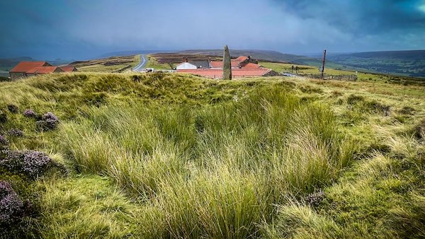
Cockpit Hill and Blakey Stone. The Lion Inn is behind .
Blakey Howe, Lion Inn, Coast to Coast
Blakey Howe, also known as Cockpit Howe, is a Scheduled Monument that includes the buried and earthwork remains of a prehistoric burial mound. Sitting atop the mound is an 18th century boundary stone. It is located adjacent to the Lion Inn and sits prominently on the edge of Blakey Ridge near the summit of High Blakey Moor at 401m, and looks down on the Castleton to Hutton-le-Hole road, and the Lion Inn's car park. Rosedale Head is on the opposite side of the road, and Farndale Moor adjoins High Blakey Moor to the east. Blakey Gill is a mere 1/2 mile to its west.
Blakey Howe is about 20m wide and 2m high. A 2m high Boundary Stone caps the Barrow, bearing the initials T. D. These are the initials of Thomas Duncombe who was once the owner of the Duncombe Estate in the early 18th century. The Stone is also Scheduled. It is thought that the stone may be a re-used prehistoric standing stone, re-dressed where it now stands.
The purpose of a Round Barrow is to provide a burial place for its occupant/s and they usually occur in prominent locations and often in clusters, as our modern cemeteries. They generally date to 2400-1500 BC, i.e. to the Late Neolithic Period. There are many other nearby Round Barrows, e.g. Kettle Howe and Little Blakey Howe, at the side of the road, a little further south, and Flat Howe a little further north, again on the roadside.
Blakey Howe
To appreciate the size of Blakey Howe it is best to step back a little and then to look at it. It is thought to be surrounded by a ditch that has become filled in. That is the usual pattern of creating an ancient burial cairn, although there is no direct evidence of the ditch so far. Ancient Barrows were thought to often double up as boundary markers.
Blakey Howe Lion Inn
Blakey Howe is also known as Cockpit Hill, and used to be the site of cock fighting in the 18th century. The hill itself is a dug-out round barrow, which has been topped with a boundary stone. The Coast to Coast footpath passes within yards of the monument. There is a magnificent panorama over the Rosedale Valley from the top of Blakey Howe.
Blakey Howe Cockpit Hill
The girth of Blakey Howe is considerable and it sits upon a 401m contour at the very edge of the Blakey Ridge. The summit of the spinal Ridge is set only 7m higher, achieved at Flat Howe, 200m further north.
Another Face of Blakey Stone
Viewing Blakey Stone from the south east permits a view over High Blakey Moor and Farndale Moor. These Moors are pockmarked with disused coal mines. There are about 100 of them all cramped into a small area, mostly nestled just above the spring of Blakey Gill.
Blakey Cock Pit
There is a 6m diameter depression at the top of the Howe that was caused by an earlier excavation. In later years the depression was used as a cock fighting pit. Lion Inn is seen in the background and to the south east (upper left) is Rosedale.
Coast to Coast Trail Guide
Hiking the Coast to Coast
"Hiking the Coast to Coast" is a digitally enhanced eBook available from Apple Books for all people who have either a Mac, an iPhone or an iPad, and is designed to accompany you on your walk of the Coast to Coast path. The trail guide contains Ordnance Survey maps and other advanced mapping features, step by step directions, hundreds of colour photographs, details of the route, its conditions in different weather and research snippets relating to places of interest along the way.
