Boredale, Patterdale, Coast to Coast
More Articles in the Patterdale to Haweswater subsection
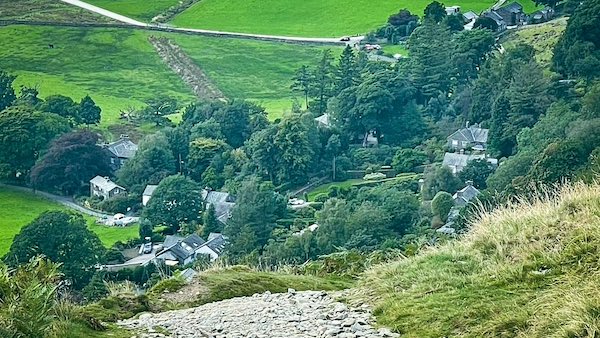
Looking down to Rooking from the path to Boredale Hause
Boredale Hause, Rooking, Coast to Coast
Boredale Hause is the high saddle that links Patterdale with the secluded trough of Boredale, forming a natural gateway between the eastern fells. In Lakeland usage a “hause” is a pass or col, and here the crossing is shaped by Stonebarrow Gill, which gathers its waters from the plateau above and drains south towards Rooking. The climb to the Hause from Patterdale is short but steep, rising through the hamlet of Rooking onto a broad, grassy shelf that carries the ridge between Place Fell and the long spine of High Street. Today the Hause is a significant footpath hub, where routes converge from Patterdale, Boredale, Beda Fell, Hartsop, Place Fell and the Roman road on High Street, making it one of the area’s key decision-points for walkers.
Looking back to Patterdale Valley
From partway up the climb to Boredale Hause, the view drops steeply back over Patterdale, with the clustered village and the valley floor framed by the surrounding fells. This old route once carried worshippers between Patterdale and the chapel at Boredale Hause, its line still following the traditional ascent above Rooking. Even from this modest height the sweep of the valley below sets the scene for the climb ahead and the wider crossing between the two valleys.
Rooking Path to Boredale Hause
From Rooking the path climbs diagonally across the southern flank of Place Fell, rising steadily toward the saddle of Boredale Hause. In summer the mountainside here is thick with tall bracken, the trail threading a clear line through the dense green as it gains height. Much of this section was stone-pitched in 2018, giving the ascent a durable, stepped surface that guides walkers confidently toward the broad plateau above.
Hartsop Dodd and Caudale Head
From the line of Rooking Gill the distinctive triangular profile of Hartsop Dodd rises clearly in the middle distance, its neat grassy ridge climbing to 618 metres. Behind it, forming the higher skyline, stand Caudale Head and Stoney Cove Pike at 763 metres — the broad shoulders of the eastern fells. These summits sit well beyond the Boredale flank, but from this vantage their layered forms lend depth and scale to the view from the ascent to Boredale Hause.
Sheffield Pike and Glenridding Dodd
Looking back from the rising path to Boredale Hause reveals a fine panorama over Glenridding, framed by the twin heights of Sheffield Pike and Glenridding Dodd. Sheffield Pike, at 675 metres, forms the broad, dark shoulder above the village, while the smaller Glenridding Dodd stands neatly below it at 442 metres. Together they create the backdrop to the head of Ullswater and give a strong sense of the valley’s enclosed, amphitheatre-like setting.
Oxford Crag and Arnison Crag
From Boredale Hause the view swings south-west towards Oxford Crag and Arnison Crag, two bold outcrops that stand prominently above the lower Patterdale slopes. Behind them rises the more imposing mass of St Sunday Crag, whose long ridge forms the northern arm of Deepdale. Beyond this again, the broken skyline of the Helvellyn range lifts into view, adding depth and a sense of scale to the panorama from the saddle.
Boredale Hause Saddle Viewpoint
Boredale Hause forms a broad grassy saddle between Patterdale and the quiet length of Boredale, its open plateau acting as a natural crossroads for several well-used fell paths. From this height the view spreads widely in all directions: the south-western skyline is dominated by Arnison Crag, Oxford Crag and the bold flank of St Sunday Crag, with the higher Helvellyn range towering beyond. It is a place of spacious perspectives and shifting ridgelines, typical of these eastern fells.
Boredale Chapel Chapel-in-the-Hause
Boredale Chapel, traditionally known as Chapel-in-the-Hause, stands as a low ruin on the grassy plateau of Boredale Hause, marking the former place of worship for the scattered communities of Patterdale and Boredale. Set between the two valleys, it once served both sides equally, and the walk from Patterdale to the chapel would have taken parishioners around thirty minutes. Though only foundations remain, the site still conveys a strong sense of the chapel’s role as a shared meeting point on this upland pass.
Place Fell - Boredale Horseshoe
Place Fell dominates the northern flank of Boredale and forms the anchor of the Boredale Horseshoe, a graceful circuit tracing the ridge above the valley. The horseshoe runs southwards along Place Fell’s broad back before descending to Garth Heads at the head of the dale, then returns north along the narrower ridge of Beda Head. From Boredale Hause the fell’s bulk is unmistakable, setting the western wall of the valley and shaping much of the skyline toward Patterdale and Ullswater.
View along Boredale Valley
A short walk north-west from Boredale Hause leads to the edge of Boredale Crag, where the ground falls away sharply and the full length of the Boredale valley opens beneath you. At the far end of the dale stands Hallin Fell, a 388-metre Wainwright whose bulk blocks the view towards Ullswater. The valley floor forms part of the Boredale Horseshoe, with the ridge of Beda Fell tracing the eastern skyline as the circuit loops back towards the Hause.
Hiking the Coast to Coast trail guide
Hiking the Coast to Coast is a digitally enhanced eBook designed to accompany you on your journey along the Coast to Coast path. Available on Apple Books for iPhone, iPad and Mac, the guide includes:
• Mapping with interactive features
• Step-by-step route directions
• Hundreds of colour photographs
• Route conditions in different weather
• Historical and cultural points of interest
Whether you’re planning your trip or already on the trail, it’s a practical and beautifully illustrated resource to carry with you.



