Stonethwaite, Borrowdale - Coast to Coast
More Articles in the Rosthwaite to Grasmere subsection
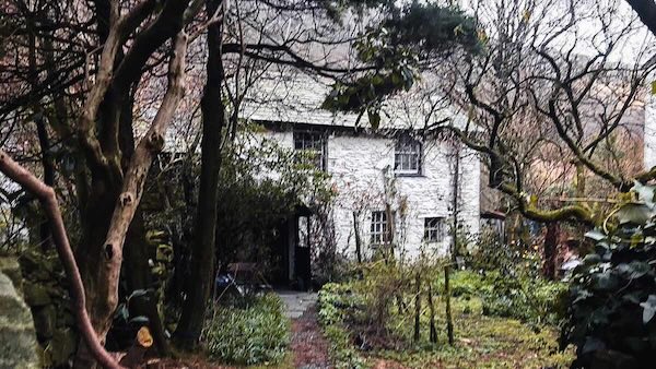
Stonethwaite Village Cottage
Stonethwaite Village, Borrowdale, Coast to Coast
Stonethwaite is a tranquil Lakeland hamlet in the heart of Borrowdale, just a mile south of Rosthwaite. It lies within a wide alluvial plain framed by the Borrowdale Fells to the west and Stonethwaite Fell to the east. The village nestles beside the Stonethwaite Beck, whose waters join the River Derwent a short distance north, flowing onward to Derwent Water.
Stonethwaite Bridge links the village with the Cumbria Way and the Coast to Coast path, which both climb toward Greenup Edge — a route renowned for its mix of riverside woodland, open meadows, and far-reaching views.
Low Buck How Stonethwaite
The Stonethwaite Valley branches south from the Jaws of Borrowdale, running past Rosthwaite and Stonethwaite toward Eagle Crag. Midway along, a second valley joins from the west — descending from Seathwaite and Seatoller. At their meeting point, the fell of Bessyboot stands prominently on the corner, dividing the two valleys with its twin crags, Low and High Buck How.
Stonethwaite Valley Meadows
The lower Stonethwaite Valley opens into a broad floor of alluvial meadows, where floodplains shimmer with wild grasses and meadow flowers. Between the flanking slopes of the Borrowdale Fells, these pastures form a tranquil counterpoint to the rugged heights above.
Stonethwaite Village
Stonethwaite Village is a small cluster of whitewashed houses, tea shops and b&bs, located on the west bank of Stonethwaite Beck. Although there is a road to it there are no parking facilities, and the village is therefore mostly free of traffic.
Stonethwaite Bridge Borrowdale
Stonethwaite Bridge is a single-span packhorse bridge crossing the Stonethwaite Beck just west of the village. It connects the lane from Rosthwaite to the Coast to Coast and Cumbria Way paths. The bridge likely dates from the late 18th or early 19th century and was built to serve the packhorse and farm traffic linking Borrowdale’s isolated hamlets. Constructed from local Borrowdale volcanic stone, it features a gently cambered arch and traditional parapets, blending naturally with the valley scenery.
Stonethwaite Farm
Stonethwaite Farm was owned by the monks of Fountains Abbey in Yorkshire from around 1195, until the monks of Furness complained to King Edward II about their presence in Borrowdale. Rather than resolving the dispute, the King seized the property, later selling it back to Fountains Abbey for £2 — almost a century later. Today, Stonethwaite Farm remains a traditional working hill farm, home to about 800 Herdwick sheep grazing 500 lowland acres and 3,000 fell acres. The hardy Herdwick has a double fleece — a woolly undercoat and a coarse, hairy outer coat that resists the driving rain of Borrowdale. The outer fibres are hollow and water-shedding, giving the breed its famed resilience. Herdwicks are also hefted, meaning they roam freely without fencing, instinctively returning to their home territory on the fell.
Stonethwaite Village Borrowdale
Stonethwaite is a tiny, whitewashed village tucked deep in Borrowdale, reached by a narrow lane branching south from Longthwaite. Despite its size, it offers several welcoming inns and guesthouses, making it a peaceful base for walkers exploring Greenup Edge and the surrounding fells.
St Andrews Church Stonethwaite
St Andrew’s Church stands just beyond the village centre at the foot of the north-west arc of Low Buck How. Its white rough-cast frontage contrasts with the muted tones of its rear walls, while the churchyard itself is notably peaceful. Dating back to around 1200, the church retains a single bell. Its pulpit was brought here from Mardale Church after Haweswater was dammed and the village of Mardale Green submerged in 1937.
Allisongrass Crag and Broad Haystack
Above the west bank of Stonethwaite Beck rise a series of rugged outcrops — Broad Haystack, Hanging Haystack, Bull Crag, and Allisongrass Crag. Between them, the twin streams of Little Stranger Gill and Big Stranger Gill descend sharply to the beck, tracing bright silver lines through the bracken and fellside turf.
Cumbria Way Eagle Crag
Eagle Crag, framed by Long Band, stands at the head of the Stonethwaite Valley and is a constant landmark along this stretch of the Coast to Coast path. From Rosthwaite to the north and Greenup Edge to the south, its rugged outline dominates the skyline. This view, from near Stonethwaite, shows the crag midway between those two points.
Take the Coast to Coast Guide With You
Available on Apple Books — £12.99
Hiking the Coast to Coast combines step-by-step route directions, interactive mapping, hundreds of original photographs and information about the landscapes, history and places encountered along the route.
© 2026 Roy McKee · Coast to Coast
Contact - Privacy. - Terms


