Dollywaggon Pike, Grisedale - Coast to Coast
More Articles in the Grasmere to Patterdale subsection
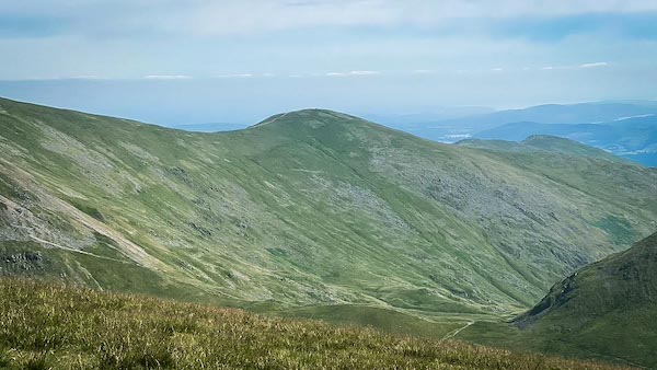
Looking across Fairfield Brow and Great Rigg from the summit of Dollywaggon Pike – southern gateway to the Helvellyn ridge on the Coast to Coast path
Dollywaggon Pike, Grisedale Coast to Coast
Dollywaggon Pike (858 m) is a Wainwright fell marking the southern end of the Helvellyn ridge. It rises steeply above Grisedale Tarn, its south-western slopes smooth and grassed, contrasting with the rugged rock faces on its eastern side. From the Coast to Coast path between Grisedale Tarn and Patterdale, walkers enjoy fine views of its crags and those of neighbouring peaks including High Crag, Nethermost Pike, The Tongue, Ruthwaite Cove and Striding Edge. The lower south-west flank of the fell is known as Willie Wife Moor. A broad col links Dollywaggon Pike with Seat Sandal (736 m), its southern neighbour.
Hause Gap Pass Dollywaggon Pike
Hause Gap forms the high col between Seat Sandal and Fairfield, where the Coast to Coast path crosses through a break in the old boundary wall. Just beyond the gap, unseen in its hollow, lies Grisedale Tarn — with the dark slopes of Dollywaggon Pike rising steeply above.
Dollywaggon Pike South Face Ascent
Dollywaggon Pike rises steeply from every approach. The easiest ascent from Grisedale Tarn follows its north shore, where the zigzag path softens the climb up the sheer southern slope. A more direct line begins from the col with Seat Sandal, marching straight to The Post on Dollywaggon’s summit ridge.
Dollywaggon Pike Zigzag Path
The zigzag path up Dollywaggon Pike is a favourite with wild campers at Grisedale Tarn. From its slopes there are wide views to Seat Sandal, Fairfield, and St Sunday Crag, and downward to the glittering waters of Grisedale Tarn. Near the summit, the view opens out along the Grisedale Valley and eastward to High Crag.
Dollywaggon Pike Stone-Pitched Path
The steep path up Dollywaggon Pike has been expertly stone-pitched, making the ascent or descent safer and more stable. Its sinuous curves ease the gradient of the climb, and looking back rewards walkers with fine panoramic views across Grisedale Tarn and Seat Sandal.
St Sunday Crag from Dollywaggon
From the brow of Dollywaggon Pike there’s a commanding prospect across the Grisedale Valley to St Sunday Crag, its ridges standing proud against the skyline. As the climb continues, the panorama widens to reveal the full grandeur of the Helvellyn range and the surrounding mountainscape.
The Post Dollywaggon Pike
A metal marker known as The Post stands on the brow of Dollywaggon Pike, where the civil parish boundary crosses the main path. From here, a narrow trail follows the boundary line southwards from Seat Sandal and Dunmail Raise, continuing over the summit ridge of Dollywaggon.
Dollywaggon Pike Main Summit
Dollywaggon Pike’s principal summit, recognised by Wainwright at 858 m, crowns the ridge with wide views to Fairfield and Grisedale Tarn. From this height, The Tongue forms the eastern wall of Ruthwaite Cove, descending steeply toward the Grisedale Valley.
Dollywaggon Pike Second Summit
West of the main top lies Dollywaggon’s lesser summit, perched above the southern rim of Ruthwaite Cove. More sharply defined than the true summit, it drops steeply eastward into the cove, its crest scattered with rough, exposed rock and weathered outcrops.
Steel Fell and Wythburn Valley
From Dollywaggon Pike’s summit, the view west spans Willie Wife Moor to the 553 m peak of Steel Fell. Beyond lie the ridges of Wythburn Valley, framed by Ullscarf’s broad spine. On the north-east wall, Nab Crags stand clear, while in the far distance, the twin silhouettes of Glaramara and Green Gable rise above the haze.
Fairfield Brow and Great Rigg Ridge
Looking south-east from Dollywaggon Pike, Fairfield’s western crags rise steeply to Cofa Pike, with the ridge extending onward to Great Rigg. The ascent path from Hause Gap to Fairfield’s 873 m Wainwright summit is clearly visible, tracing the mountain’s sweeping upper slopes.
Hiking the Coast to Coast trail guide
Hiking the Coast to Coast is a digitally enhanced eBook designed to accompany you on your journey along the Coast to Coast path. Available on Apple Books for iPhone, iPad and Mac, the guide includes:
• Mapping with interactive features
• Step-by-step route directions
• Hundreds of colour photographs
• Route conditions in different weather
• Historical and cultural points of interest
Whether you’re planning your trip or already on the trail, it’s a practical and beautifully illustrated resource to carry with you.



