Blakeley Raise, Kinniside Common - Coast to Coast
More Articles in the St Bees to Ennerdale Bridge subsection
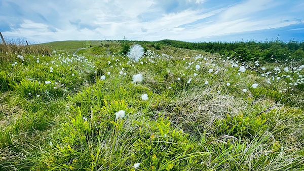
Cotton Grass near Kinney How on Blakeley Raise
Blakeley Raise Fell, Kinniside - Coast to Coast
Blakeley Raise (389 m) is a gently rounded fell on Kinniside Common, sitting slightly higher than its better-known neighbour, Dent Fell (352 m). Modest in height and appearance, its grassy dome is crowned by a neat summit cairn, located near the boundary of the Greenthwaite Plantation. The fell is best known for the prehistoric Blakeley Moss Stone Circle and the Great Stone of Blakeley, both located near the foot of its north-west slope beside the Coast to Coast path. Though unassuming, Blakeley Raise now lies within the newly expanded Wild Ennerdale National Nature Reserve, giving it renewed ecological and historical significance.
Freedom to Roam Blakeley Raise
Horses from Bradley’s Riding Centre wander across the lower slopes of Blakeley Raise, some following a tractor while others pause to browse the rough pasture. Against the backdrop of open fells and wide Cumbrian skies, they seem perfectly at home in this peaceful farming landscape.
Blakeley Raise to Dent Fell & Flat Fell
Looking back from the grassy slopes of Blakeley Raise, the eye is drawn across Scarney Brow to the knuckled ridges of Dent Fell and the rounded dome of Flat Fell. Beyond, the twin summits of Lowther Park emerge subtly above the wooded horizon. Although Flat Fell is not one of Wainwright’s Lakeland fells, its graceful profile forms an unmistakable feature of the western Coast to Coast panorama.
Summit Cairn Blakeley Raise
The rounded summit dome of Blakeley Raise rises gently from the surrounding fell, its solitary cairn marking the highest point at 389 metres. Simple and unassuming, this broad grassy top captures the quiet character of the western Lake District and provides a memorable milestone for Coast to Coast walkers.
Lowther Park from Blakeley Raise
From the summit of Blakeley Raise, the twin tops of Lowther Park rise above their dark conifer plantations, their contrasting colours making them easy to distinguish from the surrounding fells. On a clear day, the distant structures of Sellafield can be glimpsed in the shallow dip between Lowther Park and neighbouring Swarth Fell, adding an unexpected feature to this otherwise peaceful panorama.
Whoap Ridge and Valley Backwall
The smooth, whaleback ridge of Whoap rises prominently from the valley below, becoming the defining feature of the eastern panorama from Blakeley Raise. Beyond it, Lank Rigg, Iron Crag and Caw Fell unfold in successive layers, before the distant summit of Haycock brings the western skyline to a dramatic conclusion.
Kinney How and Red Moss
From Kinney How, the felled slopes of Red Moss reveal the western edge of the Wild Ennerdale landscape restoration area. Beyond, the valley extends eastwards past Heckbarley, Grike and Crag Fell, where native woodland is gradually reclaiming the fellsides. In the far distance, the broad ridge of Whoap closes the horizon.
Blakeley Raise Forestry Path
The northern flanks of Blakeley Raise are threaded with forestry tracks, their winding course framed by deep conifer greens and purple heather. Near Kinney How, the route passes between Greenthwaite and Grike on the edge of the Wild Ennerdale landscape restoration area, where woodland, open fell and quiet meadows combine to create one of the Lake District’s most peaceful landscapes.
Greengill Tongue and Comb Beck
From the valley of Comb Beck, the grassy spur of Greengill Tongue rises between the streams of Comb Beck and Stinking Gill. Beyond, the lower eastern slopes of Blakeley Raise climb steadily towards Kinney How, revealing the gentle contours that characterise this quieter corner of the western Lake District.
Stinking Gill Blakeley Raise
Looking north from the ford, Stinking Gill threads its way between the eastern slopes of Blakeley Raise and the rough moorland of Langrigg Moss. The stream provides a natural lead into the landscape, its winding course guiding the eye towards the higher ground beyond.
Bomery Gill Blakeley Raise
Looking back from Burn Edge, the shallow valley of Bomery Gill forms a distinct fold in the south-east slopes of Blakeley Raise. Hidden below the grassy hillside, the stream follows this natural corridor eastwards to join the River Calder, its course revealed only by the shape of the land.
Hiking the Coast to Coast trail guide
Hiking the Coast to Coast is a digitally enhanced eBook designed to accompany you on your journey along the Coast to Coast path. Available on Apple Books for iPhone, iPad and Mac, the guide includes:
• Mapping with interactive features
• Step-by-step route directions
• Hundreds of colour photographs
• Route conditions in different weather
• Historical and cultural points of interest
Whether you’re planning your trip or already on the trail, it’s a practical and beautifully illustrated resource to carry with you.



