Greenup Edge, Coast to Coast
More Articles in the Rosthwaite to Grasmere subsection
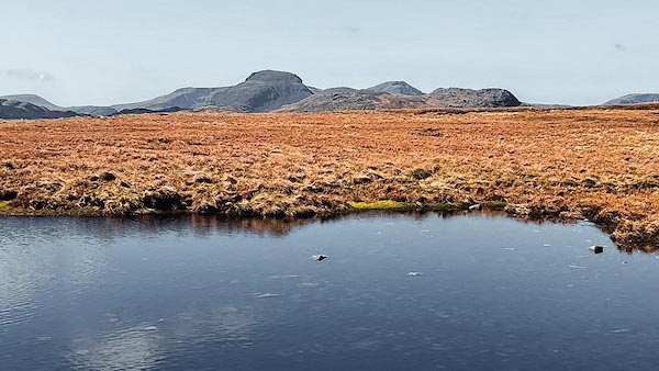
Pond close to High Raise on Greenup Edge
Greenup Edge, Grasmere Common, Coast to Coast
Greenup Edge is a high moorland ridge forming an east–west watershed between Borrowdale and Far Easedale. The Coast to Coast path climbs steeply from the Stonethwaite Valley to cross its broad, grassy col before descending towards Grasmere. The ridge extends northward from Thorn Crag in the Langdale Pikes, over Thunacar Knott (723 m), High Raise (762 m), and Low White Stones, before reaching Ullscarf (726 m). From its height, Greenup Edge commands open views across the Central Lakeland Fells — from Eagle Crag and Sergeant’s Crag below to the distant shapes of Helvellyn and Skiddaw.
Greenup Edge Grasmere Common
From the point where the Coast to Coast path crosses Greenup Edge, a glance to the south-west reveals Low White Stones and, beyond it, the long slopes rising to High Raise — the summit of this broad upland watershed. The ridge here forms part of Grasmere Common, linking the Langdale Pikes with Ullscarf in an unbroken sweep of moorland grass and peat. In clear weather, the rolling heights seem to merge with the sky, giving the sense of walking along the very spine of Lakeland.
High Raise - Central Fells
High Raise — also known as High White Stones — stands at 762 m, the highest summit of the Central Lakeland Fells and one of the finest viewpoints in the district. Its central position gives a commanding panorama across Lakeland: Glaramara rising to the west, Great Gable beyond, and the long ridges of the Langdale Pikes sweeping south. From this quiet height the fellwalker can trace almost every major range of the Lakes, circling the horizon in one unbroken view.
Langstrath Valley from Greenup
From Greenup Edge the Langstrath Valley stretches away to the west, framed by the steep western face of Stonethwaite Fell. Distinct upon the fellside are the dark walls and buttresses of Black Wall, South Crag, High Buzzard Knott, and Pinnacle Bield, their cliffs forming a dramatic arc above the beck. Between South Crag and High Buzzard Knott, the twin Ribby Gills cut their way down toward the valley floor, while Stake and Lining Crag rise opposite — a landscape of ridges, gullies and glowing rock faces.
Low White Stones Greenup Edge
Low White Stones, at 730 m, marks the point where the ridge of Greenup Edge begins its broad descent northward before rising again toward Ullscarf. From here the land opens into the wide saddle of the Greenup basin, with Long Crag forming the rocky rim to the north-west. The fell’s pale outcrops and windswept turf make this a natural boundary between the higher domes of High Raise and the gentler moorland beyond — a quiet height overlooking Borrowdale and the central watershed of Lakeland.
Glacial Geography at Greenup Edge
Valley Interfluve
Greenup Edge forms the broad upland ridge separating the glacial valleys of Borrowdale and Grasmere.
Glacial Trough Intersection
Both valleys were deepened by powerful trunk glaciers, leaving the Edge as a relatively subdued divide between two U-shaped troughs.
Rounded Summit Profile
Unlike sharp arêtes such as Kidsty Pike, Greenup Edge has a smoother, more rounded form reflecting less intense back-to-back erosion.
Tributary Becks
Greenup Gill and Langstrath Beck descend steeply from the ridge, occupying valleys shaped and enlarged by glacial meltwater.
Post-Glacial Peat Formation
The broad, often boggy ground on the Edge reflects poor drainage following ice retreat and the gradual accumulation of peat.
Routeway Logic
Its relatively gentle crest explains why Greenup Edge has long served as a crossing point between Borrowdale and Grasmere.
Sergeant's Crag and Eagle Crag
From Low White Stones the eye follows the long drop of the ridge to the twin summits of Sergeant’s Crag and Eagle Crag, standing like sentinels above the Langstrath Valley. Although only their upper slopes are visible from this height, their scale is unmistakable — the rugged cap of Sergeant’s Crag at 571 m forming a striking Wainwright on the rim of the fell. Below, the rocky terraces and grassy ledges merge into the deep trench of Langstrath, a classic view of Borrowdale’s western edge.
Eagle Crag and Skiddaw View
Looking north from Greenup Edge, the ridge drops away to the sharp summit of Eagle Crag, standing proud at the end of the fell’s northern spur. Beyond it lies a sweeping panorama over Stonethwaite Valley and the merging valleys of Langstrath and Borrowdale. Across this broad landscape rises Skiddaw, 931 m, the great northern Wainwright, with Keswick nestled at its base and Bassenthwaite Lake glinting to the west — a view that captures the full breadth of Lakeland from fellside to far horizon.
Coast to Coast Path on Greenup
The Coast to Coast path climbs from the Greenup basin by way of Lining Crag, then crosses the broad saddle of Greenup Edge on its journey between Borrowdale and Grasmere. Here the path threads a line of small cairns across open turf and peat hags, leading toward the pass between Birks and Flour Gill. From this height the view northward takes in the length of Borrowdale, with the cairns standing as quiet markers along one of the most elevated stretches of the entire Coast to Coast route.
Ullscarf and Wythburn Valley
From Low White Stones, the view north reveals Ullscarf descending in long, heathered slopes toward the Wythburn Valley — the next valley north of Far Easedale and leading directly to Thirlmere. Ullscarf, at 726 m, is the second-highest summit on the Greenup ridge, standing between High Raise (762 m) and Thunacar Knott (723 m). The valley alignment can be deceptive here, easily mistaken for the Easedale route, but the true northern drainage cuts steeply down to the hidden waters of Thirlmere.
Hiking the Coast to Coast trail guide
Hiking the Coast to Coast is a digitally enhanced eBook designed to accompany you on your journey along the Coast to Coast path. Available on Apple Books for iPhone, iPad and Mac, the guide includes:
• Mapping with interactive features
• Step-by-step route directions
• Hundreds of colour photographs
• Route conditions in different weather
• Historical and cultural points of interest
Whether you’re planning your trip or already on the trail, it’s a practical and beautifully illustrated resource to carry with you.



