Asper Stone, Shap, Coast to Coast
More Articles in the Haweswater to Orton subsection
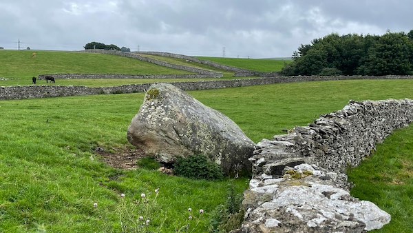
Asper's Field Stone, looking at the north west side
Asper Stone, Shap - Coast to Coast
Set in open pasture to the east of Shap, Asper Stone stands as part of the wider Shap Stone Avenue, a prehistoric alignment that once extended across the valley in a sweeping ceremonial route. Though less prominent than Goggleby Stone, its position within the surrounding field system reflects a broader pattern of standing stones, fallen blocks, and lost markers that together define one of the most extensive prehistoric landscapes in Cumbria.
🏛️ Insight – Archaeology
Shap Stone Avenue, Cumbria
Features and Terms
Processional Avenue
A linear or curving alignment of standing stones, thought to have guided ceremonial movement through the landscape. At Shap, the stones form a broad arc rather than a straight line, suggesting a more fluid route across the valley floor.
Glacial Erratics
Many of the Shap stones, including the Goggleby Stone, are likely glacial erratics—large boulders transported and deposited by ice during the last glaciation, later selected and erected by prehistoric communities.
Cup Marks
Shallow, man-made depressions found on stone surfaces. The Goggleby Stone bears a cup mark on its north face, often associated with ritual or symbolic marking in Neolithic and Bronze Age contexts.
Megalithic Landscape
The stones are not isolated monuments but form part of a wider ceremonial landscape, incorporating standing stones, barrows, and alignments across the eastern edge of the Lake District.
Shap Context and Alignment
The Goggleby Stone is one of the principal surviving members of Shap Stone Avenue, a major prehistoric complex in eastern Cumbria. The avenue forms a broad arc to the west of Shap and east of the River Lowther, running roughly from north-north-west to south-south-east across open farmland.
Immediately to the north lies Asper’s Field, home to another substantial monolith—the Asper’s Field Stone—so that both stones sit within a third of a mile of Shap Abbey. Together they hint at a once more extensive alignment linking ritual sites across the valley.
Other notable features within the complex include the Thunder Stone near High Buildings, the Skellaw Hill barrow, and scattered fallen stones along the former route. The Goggleby Stone itself stands around 10 feet high and has been re-erected and stabilised with a concrete base, preserving it where others have been lost or now lie recumbent.
Asper Stone Shap Valley
Asper Stone stands quietly within open pasture, its weathered form suggesting a glacial origin before being set upright as part of the wider Shap Stone Avenue.
Standing Stone Shap Fields
Less prominent than Goggleby Stone, Asper Stone forms part of a wider alignment of monoliths that once extended across the valley as a ceremonial route.
Stone Alignment Shap Valley
Across the surrounding fields, scattered stones and subtle alignments hint at the former course of the avenue, now largely lost through time and agricultural change.
Hiking the Coast to Coast trail guide
Hiking the Coast to Coast is a digitally enhanced eBook designed to accompany you on your journey along the Coast to Coast path. Available on Apple Books for iPhone, iPad and Mac, the guide includes:
• Mapping with interactive features
• Step-by-step route directions
• Hundreds of colour photographs
• Route conditions in different weather
• Historical and cultural points of interest
Whether you’re planning your trip or already on the trail, it’s a practical and beautifully illustrated resource to carry with you.



