Grange Scar, Little Asby - Coast to Coast
More Articles in the Orton to Kirkby Stephen subsection
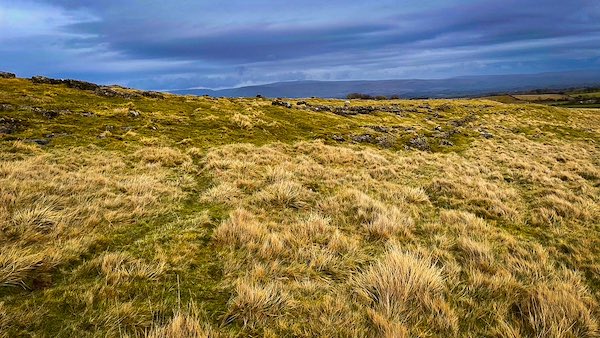
Grange Scar - most of the limestone is turf covered, but obvious when treading on it
Grange Scar, Little Asby - Coast to Coast
Grange Scar is a small area of limestone pavement separated from the much larger Little Asby Scar by the moorland road. On its western flank rises Great Kinmond, whose southern face is marked by a series of three distinctive stepped terraces extending almost to the summit.
Although the Ordnance Survey shows no public path crossing Grange Scar, numerous minor tracks thread their way through the grass, many of them formed by generations of sheep. Walkers should exercise care near the limestone pavement, where deep clints and grikes of the karst landscape are often concealed by vegetation until underfoot.
The village of Little Asby lies about half a mile to the east, with Crosby Garrett a further half mile beyond. Crosby Garrett Fell rises approximately one mile to the south-east, while Sunbiggin Tarn lies about half a mile to the south.
Lone Tree Stump Middle Busk
At Middle Busk, where Grange Scar falls towards the moorland road, a solitary weathered stump stands above the open grassland. Nearby, the low remains of a treefold are easily overlooked among the limestone and turf. Together they give this quiet corner of the scar a curious sense of continuity — the old enclosure recalling the management of trees and livestock in a landscape where shelter has always been scarce.
Little Asby Scar from Grange Scar
Across the moorland road, Little Asby Scar spreads towards the horizon in a broad sweep of limestone pavement. From Grange Scar, its broken surface is especially striking: pale clints emerge through the turf while dark grikes fracture the rock into an intricate natural pattern. Beyond lies an apparently empty upland of stone, grass and sky — one of those wonderfully open landscapes where the geology itself seems to shape the character of the walk.
Summit Cairns Grange Scar
Two modest cairns stand close together near the 340-metre contour, marking the highest ground on Grange Scar. They are small against the breadth of the landscape, yet from beside them the view opens wonderfully across Little Asby Scar and the surrounding limestone fells. With little shelter and an immense spread of sky overhead, the cairns give this otherwise understated summit a distinct sense of arrival — a quiet high point above the hidden limestone beneath the turf.
🪨 Insight - Geology
What are Limestone Pavements?
Grange Scar forms part of the extensive Carboniferous limestone landscape that stretches across the Orton Fells. Around 340 million years ago, this area lay beneath a warm, shallow tropical sea where countless shells and marine organisms accumulated to form thick beds of limestone.
During the last Ice Age, glaciers stripped away much of the overlying soil, exposing the bare limestone beneath. Since then, slightly acidic rainwater has gradually dissolved the rock along its natural joints, creating the distinctive pattern of clints, the flat limestone blocks, and grikes, the deep fissures that separate them.
Although the exposed limestone pavement appears barren at first sight, the sheltered grikes provide a unique habitat for ferns, wild flowers and other plants that thrive in the cool, moist conditions. Many limestone pavements are now protected because of their geological importance and the rare wildlife they support.
Grange Scar, together with neighbouring Little Asby Scar and Great Asby Scar, forms part of one of Cumbria’s finest limestone landscapes, where geology, wildlife and the Coast to Coast Walk combine to create a truly distinctive upland environment.
Great Kinmond Grange Scar
Great Kinmond rises to 388 metres, its southern face broken into three long natural terraces that give the fell an unmistakable profile. From Grange Scar the steps seem almost carved into the hillside, climbing one above another towards the broad summit. Against the softer grassland around Sunbiggin Tarn, they reveal the underlying structure of the limestone country on a grand scale — geology written boldly across the face of the fell.
Asket Dub, Grange Scar
At the north-eastern foot of Grange Scar, Asket Dub lies hidden in a shallow fold of the limestone ground, almost invisible until approached closely. Once holding water for much of the year, the hollow is now only occasionally flooded, leaving a quiet grassy depression beside the moorland road. Its subdued appearance contrasts with the broken limestone nearby — another small reminder that water, as much as rock, has shaped this remarkable karst landscape.
Exposed Buried Limestone
Near Asket Dub, a patch of stripped turf reveals what much of Grange Scar keeps hidden beneath its thin covering of soil. Pale limestone lies immediately below the grass, its surface already broken by the joints and fissures characteristic of the surrounding karst. The reason for the exposure is uncertain, but it offers a rare glimpse beneath the fell — revealing that this apparently soft green landscape is, quite literally, limestone country just beneath your feet.
Take the Coast to Coast Guide With You
Available on Apple Books — £12.99
Hiking the Coast to Coast combines step-by-step route directions, interactive mapping, hundreds of original photographs and information about the landscapes, history and places encountered along the route.
© 2026 Roy McKee · Coast to Coast
Contact - Privacy. - Terms


