Gallop End Limekiln, Marske
More Articles in the Reeth to Richmond subsection
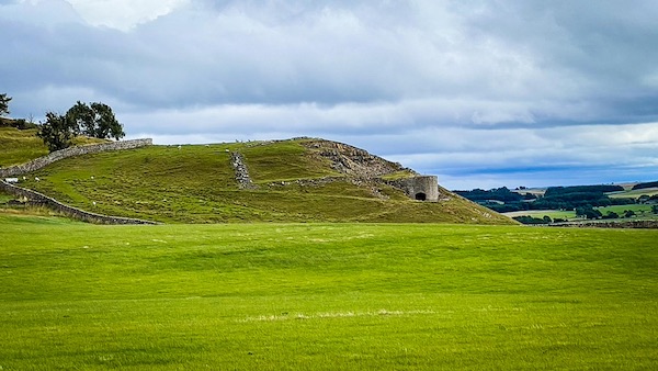
Looking north east from the field boundary at Hollins Farm.
Gallop End Limekiln, Marske, Coast to Coast
Gallop End limekiln is a prodigious disused limekiln on Gallop End, which is the rocky outcrop forming the east ridge top finger of Deer Park Wood, above the disused Gallop End Quarry and slightly east of Hollins Farm. It is midway between Marrick and Marske in Swaledale and is just outside of the boundary for the former Deer Park, a short distance from Hutton's Monument.
Gallop End Limekiln
Gallop End Limekiln blends in perfectly with the background outcrop of rock of the same colour. Unlike most it is a double limekiln. Above it is the Gallop End Quarry, now disused. The limekiln was used to make lime on-site from the limestone mined in the quarry.
Gallop End Limekiln
Gallop End can be seen from the Coast to Coast path by peering over the Deer Park wall at the wall junction as the path approaches Hard Stiles Lane. From this direction it is seen end on, projecting from the rocks below the quarry.
Gallop End, Deer Park, Marske
The Limekiln and disused quarry can also be seen from the wall alongside the Coast to Coast path at Hollins Farm, albeit a little more distant. The light top of Hutton's Monument can just be seen over the brow of the hill. The Monument has a Grade II Listing with Historic England. It dates to 1814 and commemorates Sir Matthew Hutton, whose favourite view was the hill upon which it stands.
Hollins Farm Gallop End
The Coast to Coast path passes around the west side of Hollins Farm, which has an extensive range of buildings. To its rear is Gallop End and the former Deer Park.
Coast to Coast Trail Guide
Hiking the Coast to Coast
"Hiking the Coast to Coast" is a digitally enhanced eBook available from Apple Books for all people who have either a Mac, an iPhone or an iPad, and is designed to accompany you on your walk of the Coast to Coast path. The trail guide contains Ordnance Survey maps and other advanced mapping features, step by step directions, hundreds of colour photographs, details of the route, its conditions in different weather and research snippets relating to places of interest along the way.
