Grike, Ennerdale Coast to Coast
More Articles in the Ennerdale Bridge to Rosthwaite subsection
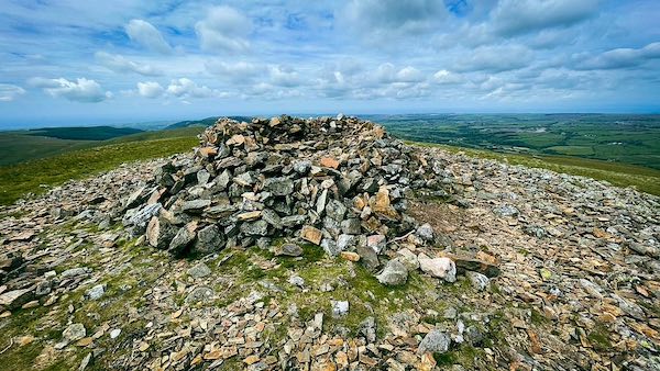
A third Cairn on Grike
Forest Track to Grike’s Summit
Grike (488m) is a western Wainwright that stands above the head of Ennerdale Water, offering a quieter alternative to the more frequented high fells of central Lakeland. It is usually approached via the forest road that winds through the Greenthwaite Plantation, running between the southern flank of Heckbarley (390m) and its southern twin, Blakeley Raise (389m). Although Heckbarley is not typically climbed—its summit is fenced off—it forms a broad shoulder on the way to Grike, offering increasingly expansive views westward towards the coast.
Grike is often combined with Crag Fell (523m), which lies to the east along the same ridge. The two summits share a commanding outlook over the Ennerdale valley, and their broad grassy flanks make for a straightforward, if sometimes boggy, traverse. For those seeking a longer outing, the route can be extended eastwards to include Lank Rigg, forming a quiet and satisfying circuit that explores the less-travelled western edge of the Lake District.
Both Grike and Heckbarley bear traces of a once-active iron mining industry. Four disused mine entrances are marked on OS maps across their lower slopes. These adits are now difficult to locate on the ground, though three are known to lie beside gills—one identified as Goat Gill, the others unnamed—cutting sharply through the fellside. While little remains of the workings today, they add a layer of human history to a landscape that otherwise feels remote and untouched.
Greenthwaite's Mossy Margin
The forestry road through Greenthwaite Plantation provides a pleasant and colourful start to the ascent of Grike. In summer, open glades reveal views towards Heckbarley and the villages below. The plantation occupies the lower northwestern slopes of Blakeley Raise and is separated from Heckbarley by just a narrow gap in the trees.
Fellside Flow to Heckbarley’s Top
Although Heckbarley’s 390m summit is bypassed on the walk to Grike, its steep, craggy north face adds both character and historical interest to the approach. The fell was once the site of small-scale iron mining, with several adits driven into its flanks. Goat Gill descends sharply from this northern face, carving a deep groove in the hillside before joining the River Ehen near Far Moorend Farm.
Forest Fringe and Fellside Grike
The forest road through Greenthwaite Plantation eventually meets the Old Mining Road at Kinney How, a broad junction below the flanks of Heckbarley. From here, the route continues east along the old track, skirting the southern slopes of Heckbarley as it heads towards Grike. A stile on the northern side of the track gives direct access to the open fellside and leads up to Grike’s summit cairn. The transition from managed forest to open moorland is gradual but striking, with expanding views westward to the coast and inland to the high fells.
Moss and Misty River Calder
From the slopes of Grike, there is a wide view down the Calder Valley, where the river winds southward through open country. To its east lie Lankrigg Moss and Latterbarrow Moss; to the west, the valley is flanked by the footslopes of Blakeley Raise, Burn Edge, and Swarth Fell.
Summit Cairns: Stone & Shelter
The large summit cairn on Grike is known as the Stone Man. Beside it stands a second pile of stones, shaped into a rudimentary wind shelter. The size of these cairns is surprisingly substantial given the modest height of the fell — Grike being a 488m Wainwright.
Herdus Heights Beyond Crag Fell
The flat-topped and boggy Herdus (562m), along with its Wainwright parent Great Borne (616m), stands on the far side of Ennerdale Water. From the ridge between Grike and Crag Fell, the two appear as a distinctive pair. Herdus is particularly striking, with a steep upper face of dark stone that gives way to paler scree below — a bold contrast that stands out even at a distance.
Sharp Scarp of Crag Fell Ridge
Crag Fell follows Grike along the ridge, with the ground dipping from 488m to a shallow col at 451m before rising again to Crag Fell’s summit at 523m. The fell’s northern face drops steeply away as Revelin Crag — a striking scarp edge that plunges towards Ennerdale Water and gives Crag Fell its distinctive profile when viewed from below.
Weather & Wind on Grike's Saddle
A small weather station stands quietly near the saddle between Grike and Crag Fell, tucked between the ridge path and the old mining road. From this exposed perch, Crag Fell rises steeply ahead, with the smooth dome of Whoap (511m) visible in the distance.
Take the Coast to Coast Guide With You
Available on Apple Books — £12.99
Hiking the Coast to Coast combines step-by-step route directions, interactive mapping, hundreds of original photographs and information about the landscapes, history and places encountered along the route.
© 2026 Roy McKee · Coast to Coast
Contact - Privacy. - Terms