Brund Fell, Rosthwaite, Coast to Coast
More Articles in the Rosthwaite to Grasmere subsection
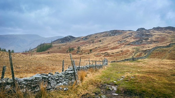
Path from Puddingstone Bank to Brund Fell and Jopplety How
Brund Fell, Grange Fell - Coast to Coast
Brund Fell (415 m) is one of three summits forming Grange Fell, located east of the Jaws of Borrowdale and roughly halfway between Rosthwaite and Watendlath. Though not the highest of the three peaks—Ether Knott reaches 419 m—Brund Fell is the Wainwright summit and offers superb views across the Borrowdale Valley. It sits between Kings How (392 m) to the west and Ether Knott to the north-east. The most accessible approach is from the bridleway between Rosthwaite and Watendlath, with a well-marked footpath branching north at Puddingstone Bank.
Brund Fell Crags from Lingy Bank
Seen clearly from Lingy Bank across the Derwent, Brund Fell rises in a dramatic crown of craggy tors. These rock-strewn knuckles cluster around the 415m summit and lend the fell its rugged character. Though not the highest top on Grange Fell, Brund’s crags are more prominent and form a memorable outline when viewed from the western side of the valley, particularly near Castle Crag.
Rosthwaite Bridge Stonethwaite Beck
Rosthwaite Bridge is a single-span packhorse bridge crossing Stonethwaite Beck on the lower slopes of Hazel Bank Drive. Constructed in the early 19th century from green slate rubble, it forms part of a historic bridleway linking Rosthwaite to Watendlath. The route passes south of Brund Fell at Puddingstone Bank before continuing toward Watendlath tarn.
Hazel Bank Bridleway
Hazel Bank is a charming leafy lane that skirts the grounds of Hazel Bank Hotel in Rosthwaite. Though initially level, the bridleway quickly finds the foot of Grange Fell and begins its ascent toward Puddingstone Bank and the higher ground of Brund Fell. It’s an ideal starting point for walkers heading to Watendlath or seeking the summit crags of Grange Fell.
Brund Fell Summit
The rocky crown of Brund Fell rises ahead, seen clearly through a break in the trees as the trail turns northeast. The rough, open ground in the foreground is Belt Knott, while the wooded slopes below are part of Frith Wood — a peaceful outlier of the greater Borrowdale woodland.
Swanesty How Brund Fell
The copse of coniferous trees at Swanesty How lies just west of Birkett’s Leap, forming a shaded threshold at the southern base of Brund Fell. This dense patch of woodland marks a transitional zone between the lower valley paths and the open fellside above. Though modest in size, it provides visual contrast and shelter, with dark green silhouettes standing out against the craggy heights of Brund Fell rising beyond.
Birkett's Leap
Birkett’s Leap is a rugged section of the bridleway that traverses the southern slope of Brund Fell. Known for its uneven terrain and natural rock features, it offers a brief but challenging ascent for walkers—and a thrilling technical section for mountain bikers. Often hailed as one of the most rewarding bridleways in the Lake District, the route twists through rocky outcrops, requiring careful footing or confident handling depending on your mode of travel.
Puddingstone Bank
At the crest of Puddingstone Bank, the bridleway offers a junction where a narrow footpath branches north. This path skirts the eastern side of a drystone wall, rising gently to a ladder stile that marks the beginning of the ascent to Brund Fell. The same route provides access to Jopplety How, a lower outcrop with fine views back towards Borrowdale. Though unfrequented, this quiet turning is the key to reaching the upper ridgeline of Grange Fell.
Brund Fell and Jopplety How
The rugged summit outcrops of Brund Fell and nearby Jopplety How emerge to the west of the dry stone wall that rises steeply from Puddingstone Bank. This scene captures the layered cragginess typical of Grange Fell, where rough tors and heathery knolls interrupt the smoother flanks of the ridge. Though modest in height, these tops offer far-reaching views over Borrowdale, with surprisingly few visitors venturing to their peaceful crests.
Take the Coast to Coast Guide With You
Available on Apple Books — £12.99
Hiking the Coast to Coast combines step-by-step route directions, interactive mapping, hundreds of original photographs and information about the landscapes, history and places encountered along the route.
© 2026 Roy McKee · Coast to Coast
Contact - Privacy. - Terms


